


| Silver Fork Canyon | |
|---|---|
| Trailheads |
Solitude Entry #1 Grizzly Gulch Trailhead |
| Location | 40.6143° / -111.6210° |
| Online Map | View on wbskiing.com |
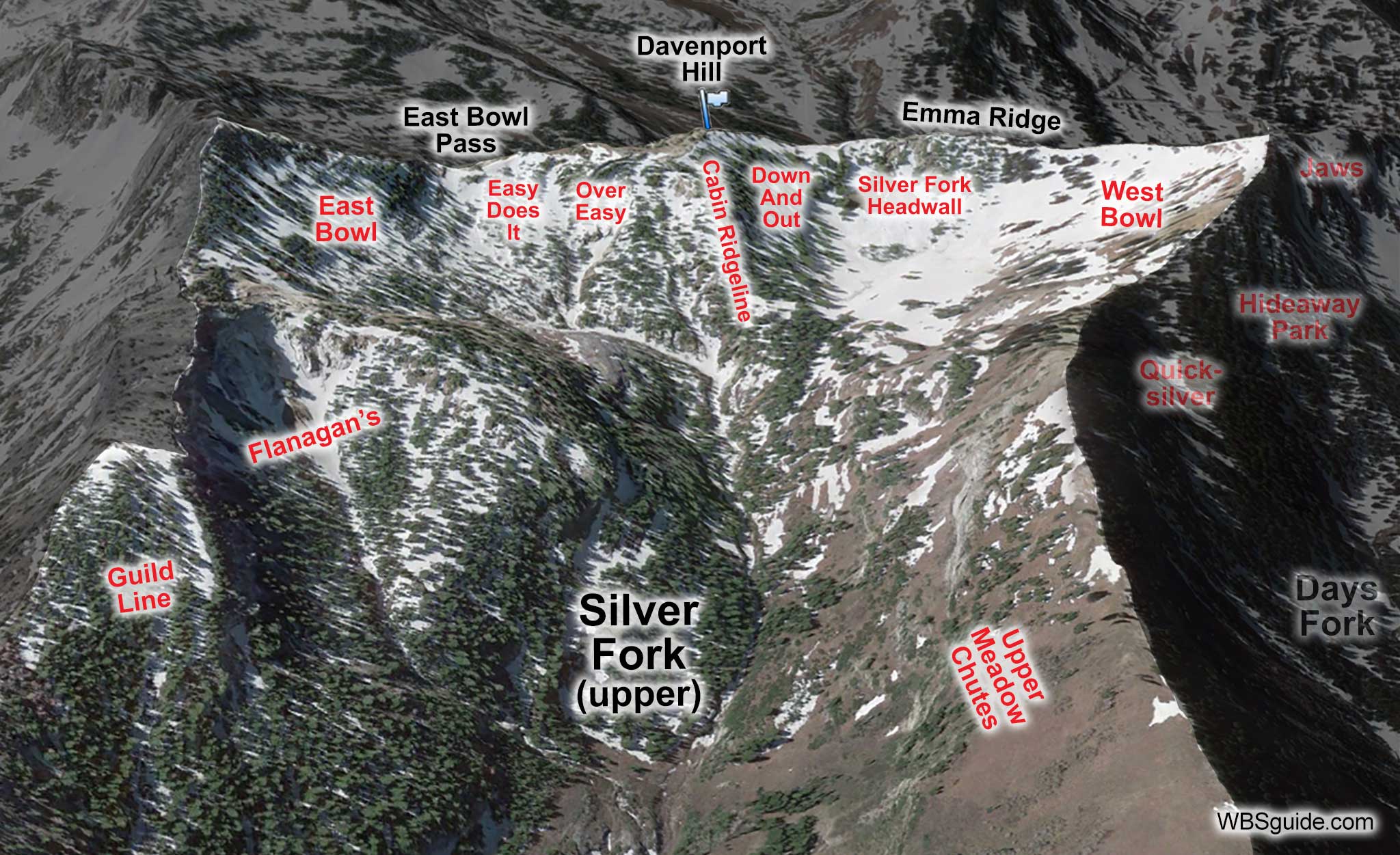
The Silver Fork drainage is located behind the Silver Fork Lodge and residential area. The drainage splits after about three-fourths of a mile with Honeycomb Canyon bearing to the left and Silver Fork continuing to the right. Days Fork is west of Silver Fork and Greens Basin is nestled at the base of the ridge that separates Silver Fork from Days Forks. Davenport Hill, which overlooks Alta, sits at the upper end of Silver Fork and divides the upper drainage into the popular East Bowl and West Bowl.
The eastern slopes of Silver Fork have the small Guild Line and Flanagan's side-canyons while the western slopes form a broad slope that is collectively called the Meadow Chutes.
Solitude Mountain Resort has asked the U.S. Forest Service for permission to expand into Silver Fork (they installed a chairlift in Honeycomb Canyon in 2002). The next time a ski area pursues your land, maybe this year or maybe in 20 years, be vocal and write your elected officials and the Forest Service. If you don't speak up and take a stand, you'll lose Silver Fork and eventually the entire Central Wasatch. It is your land.
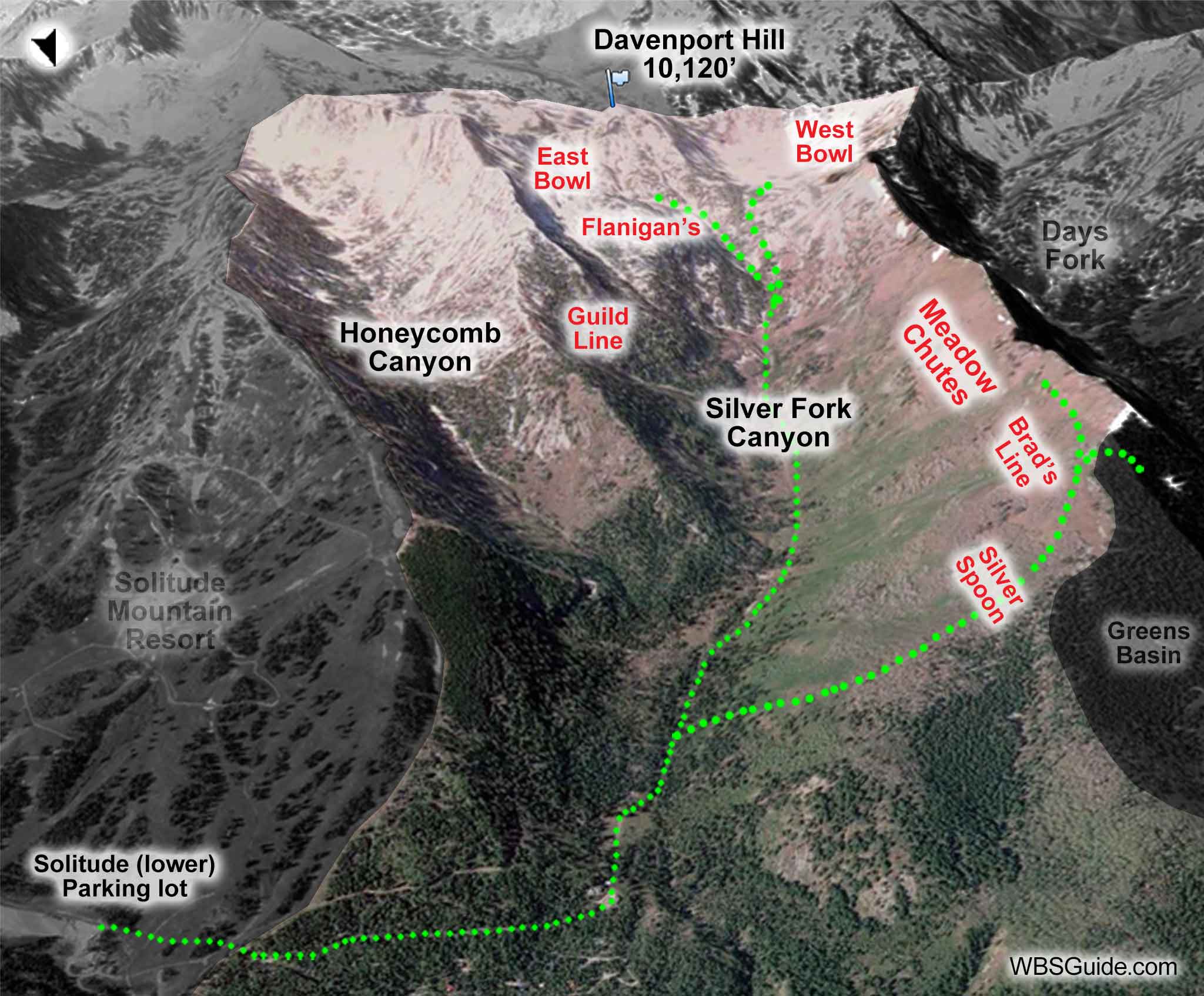
Silver Fork can be reached from either Big or Little Cottonwood canyons. The bowls in upper Silver Fork (e.g., East Bowl and West Bowl) are much easier to access from Little Cottonwood Canyon. The runs in lower and western Silver Fork (e.g., Silver Spoon, Brad's Line, and the Meadow Chutes) are easier to access from Big Cottonwood Canyon.
|
|
|
| Silver Fork from Solitude Entry #1 | |
|---|---|
| Trailhead | Solitude Entry #1 |
| Trailhead Elevation | 8,080' |
| East Bowl Pass | 10,000' |
| Total Vertical | 1,900' |
| Skinning Distance | 3.0 miles |
| Online Map | View on wbskiing.com |
There isn't convenient parking to access Silver Fork from the Silver Fork residential area. Instead, park at the west end of the lower Solitude parking lot, cross directly under the Eagle Express chairlift (cross just above tower #3, which is only about 200 feet above the chairlift terminal), and look for the snow covered cabin road on the other side of the run. Avoid the temptation to head up the Honeycomb Return trail (which is left and up-hill of the cabin road) because it will suck you into Honeycomb Canyon rather than Silver Fork.
The mostly flat and usually snow-covered road winds past several cabins. In early or late season, it is likely you will end up booting the bare road.
The trail begins at the (usually occupied) last cabin which will be on your left. You'll come to small trailhead signs about 300 feet past the last cabin, a steel gate about 700 feet past the signs, and an old outhouse (on your right) about 800 feet past the gate. It takes roughly 30 minutes to get to the outhouse from the Solitude parking lot.
The trail continues on an old jeep road along the right (west) side of the Silver Fork drainage. Near the outhouse, Honeycomb Canyon branches to your left while Silver Fork continues on the right. Avoid the deep, terrain-trap gullies further up Silver Fork (I usually skirt them to the right, but there are other options).
|
|
|
| East Bowl Pass from Grizzly Gulch | |
|---|---|
| Trailhead | Grizzly Gulch Trailhead |
| Trailhead Elevation | 8,770' |
| East Bowl Pass | 10,000' |
| Total Vertical | 1,200' |
| Skinning Distance | 1.2 miles |
| Online Map | View on wbskiing.com |
One option is to follow the directions to the top of Binx's Ridge from the Bay City Tunnel trailhead. This will put you at the top of West Bowl in Silver Fork.
Another option is to park at the Grizzly Gulch trailhead, skin to the Michigan City flats, and then head left (north) to the saddles that are observer's left or right of Davenport Hill. This will take you to the top of either the West Bowl or East Bowl.
About the name
In the 1850s Silver Fork was a huge tent city that housed miners and sawmill workers. The "city" housed 2,500 people and had eight saloons, several stores and an LDS ward. The canyon was originally named Silver Springs due to the mined ore and the "clear water" that flowed from the canyon.


