Beginner terrain
that is good as you develop your backcountry skills and when the avalanche danger is higher. Click for details.
Intermediate
terrain that requires more experience in skinning and skiing. Click for details.
Advanced terrain
that requires strong skiing and skinning skills. Click for details.
Expert terrain that is
challenging and a small mistake can have serious consequences. Click for details.
Extreme terrain
that includes insanely difficult chute skiing and beyond. Click for details.
The difficulty of this terrain
varies widely. Click for details.
This terrain hasn't
been rated. Click for details.
Although this slope was measured, slopes are not homogeneous—this should be considered approximate. Click for details.
This slope angle was not measured. If you get an accurate slope measurement, please send it to me at info@vRigger.com.
The slope angle varies widely. Click for details.
This is the general direction the slope faces. Click for details.
The Utah Avalanche Center says that dangerous avalanches are not expected in this terrain except during extreme or very unusual conditions. Click for details.
The Utah Avalanche Center says that this is generally low-angle terrain although the route may cross under steep avalanche runout zones. Click for details.
The Utah Avalanche Center says that this terrain has significant exposure to numerous commonly-occurring avalanche paths. Click for details.
The Utah Avalanche Center says that this terrain is exposed to significant avalanche hazards often with multiple terrain traps. Click for details.
This terrain can be accessed by resort skiers without skins. Click for details.
This terrain can be accessed by resort skiers without skins. Snowmobiles are allowed. Click for details.
This terrain is commonly skied by helicopter skiers. Click for details.
This terrain is commonly skied by helicopter skiers and by resort skiers without skins. Click for details.
This terrain is commonly skied by helicopter skiers, by resort skiers without skins, and by snowmobilers. Click for details.
This terrain is commonly skied by helicopter skiers. Snowmobiles are allowed. Click for details.
Snowmobiles are allowed in this terrain. Click for details.
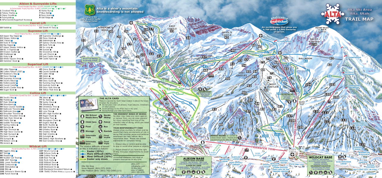
Alta Ski Resort is located 9.2 miles up Little Cottonwood Canyon road. Although Alta's parking lot is 26 miles from Brighton's parking lot by car, they are only three miles apart on skis.
As with Brighton, Alta's high base elevation (8,530 feet versus Brighton's 8,775 feet) makes it a popular location for pre- and
post-season turns.
Keep in mind that ski areas do not perform avalanche mitigation when they are closed—it's almost inevitable that the first avalanche accidents of the year occur within ski area boundaries before avalanche control work has begun.
History
The town of Alta was founded in 1865 and was home-base to miners who worked in the nearby silver mines, including the Emma and Flagstaff mines. In 1872 Alta had 180 buildings, 26 saloons, and a population of 3,000. By 1880 the boom was bust and the population was down to 300 (about where it is today) and by 1930 Alta was virtually a ghost town with only six registered voters. Alf Engen was hired in 1935 to help create what is now Alta Ski Resort. Alta began operations in 1938 (two years after Brighton and Sun Valley).
Read more about the history of Alta.


