Beginner terrain
that is good as you develop your backcountry skills and when the avalanche danger is higher. Click for details.
Intermediate
terrain that requires more experience in skinning and skiing. Click for details.
Advanced terrain
that requires strong skiing and skinning skills. Click for details.
Expert terrain that is
challenging and a small mistake can have serious consequences. Click for details.
Extreme terrain
that includes insanely difficult chute skiing and beyond. Click for details.
The difficulty of this terrain
varies widely. Click for details.
This terrain hasn't
been rated. Click for details.
Although this slope was measured, slopes are not homogeneous—this should be considered approximate. Click for details.
This slope angle was not measured. If you get an accurate slope measurement, please send it to me at info@vRigger.com.
The slope angle varies widely. Click for details.
This is the general direction the slope faces. Click for details.
The Utah Avalanche Center says that dangerous avalanches are not expected in this terrain except during extreme or very unusual conditions. Click for details.
The Utah Avalanche Center says that this is generally low-angle terrain although the route may cross under steep avalanche runout zones. Click for details.
The Utah Avalanche Center says that this terrain has significant exposure to numerous commonly-occurring avalanche paths. Click for details.
The Utah Avalanche Center says that this terrain is exposed to significant avalanche hazards often with multiple terrain traps. Click for details.
This terrain can be accessed by resort skiers without skins. Click for details.
This terrain can be accessed by resort skiers without skins. Snowmobiles are allowed. Click for details.
This terrain is commonly skied by helicopter skiers. Click for details.
This terrain is commonly skied by helicopter skiers and by resort skiers without skins. Click for details.
This terrain is commonly skied by helicopter skiers, by resort skiers without skins, and by snowmobilers. Click for details.
This terrain is commonly skied by helicopter skiers. Snowmobiles are allowed. Click for details.
Snowmobiles are allowed in this terrain. Click for details.
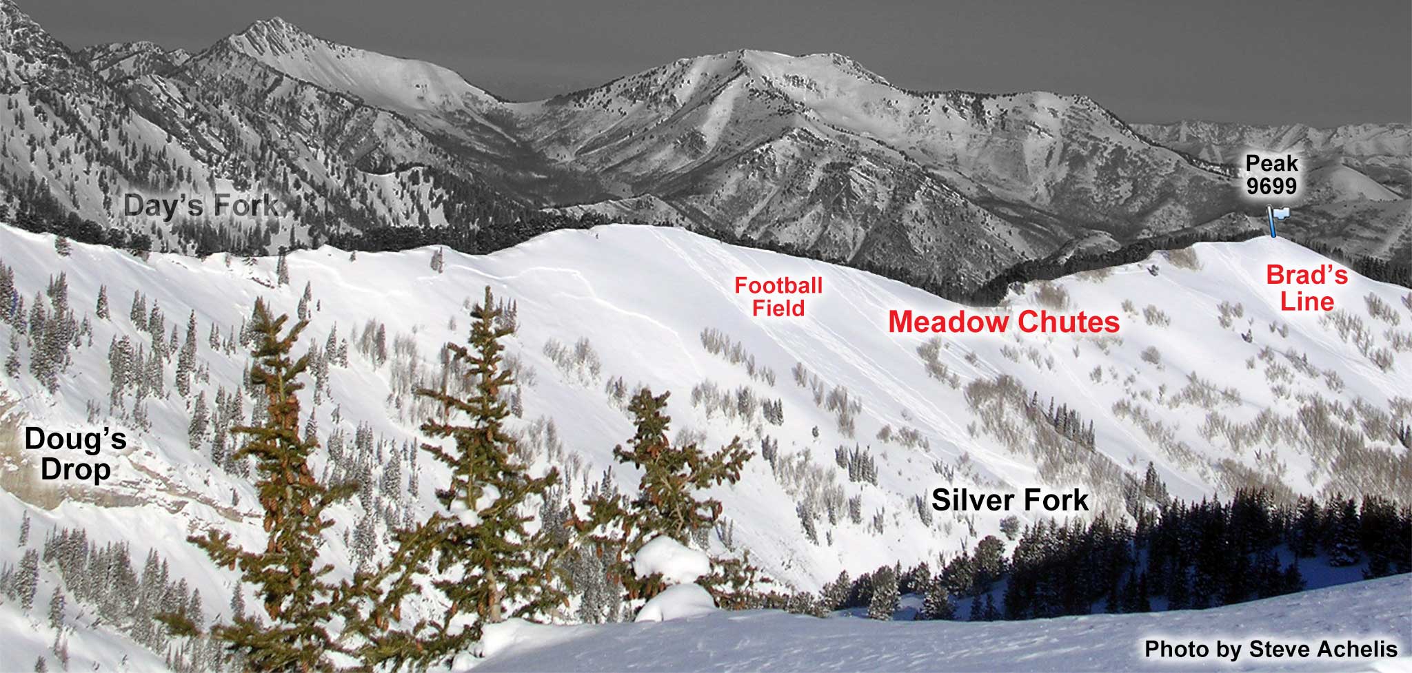
The entire western slope of Silver Fork is referred to as the Meadow Chutes. It's big, broad, and beautiful.
The terrain closer to the ridgeline is wide open and tree-less. The terrain closer to the valley bottom is steeper and a little cliffy.
The slope angle shown in this info table is more representative of the open areas near the ridgeline and is not representative of the more complex and avalanche-prone terrain, below. In fact, Ricardo Presnell died in an avalanche near here on January 27, 2010. The site of his death is referred to as Ricardo's Roll.
The basic route to the Meadow Chutes is to follow the directions to the top of Brad's Line (i.e., Peak
9699) and then continue up the Silver Fork ridgeline. You can drop in anywhere along the way, but keep in mind that some lines get steeper (or cliffy) as they near the bottom of the drainage.
Another option is to follow the directions into Silver Fork from Big Cottonwood Canyon, pass the
infamous outhouse (after about 30 minutes), and then look for, or set, a skin track heading up
to the ridge (i.e., bypassing Brad's Line).
About the name
The Meadow Chutes encompasses everything between Doug's Drop and Brad's Line (see the above photo). The area labeled Football Field in the above photo (a newer name) is part of the Meadow Chutes. Some people mistakenly call the Meadow Chutes, The Meadows, but that isn't the name.
The term "Chutes" in Meadow
Chutes is a bit of a misnomer, maybe intentionally, because the terrain primarily consists of modest gullies rather
than steep chutes.