


| Willow Fork | |
|---|---|
| Trailheads |
Solitude Entry #1 Solitude Entry #2 |
| Location | 40.6345° / -111.5990° |
| Online Map | View on wbskiing.com |
Willow Fork is on the north side of Big Cottonwood Canyon between Beartrap Fork and USA Bowl. The southern half of Willow Fork (it feels like it is the east half) offers low-angle runs that are relatively safe during periods of higher avalanche danger (e.g., Main Willow, Neil's Bullshit Bowl, and Little Willow). The Willow Fork drainage also provides access to runs on the Summit County ridgeline, including Dutch Draw, McDonald Draw, and the Monitors.
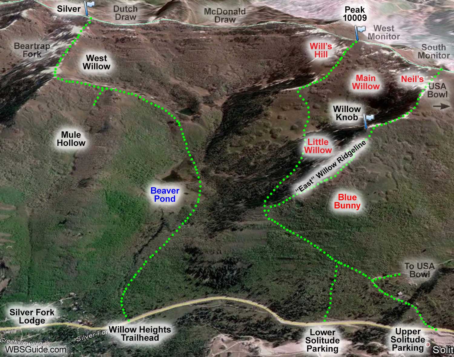
The ridgeline on the observer's right side of Willow Fork is usually called the "East Willow Ridgeline." On a map the ridge actually on the south side of Willow Fork, because Big Cottonwood Canyon bends to the south, but it sure feels east, which is why most people, including me, call it the East Willow Ridgeline.
Regardless of the name, you can ascend the ridgeline to access Blue Bunny, Little Willow, Neil's Bullshit Bowl, USA Bowl, and the South Monitor. From the top of the ridge you can head northward (it feels westward) to get to the West Monitor and Will's Hill. You can traverse eastward from the top of the ridge to access Katie's, Radar Love Bowl, No No Name Bowl, and No Name Bowl.
You can access Willow Fork and the adjacent runs from the Willow Heights trailhead or either of the Solitude parking lots. Parking near the upper Solitude parking lot is a little more convenient, but due to the limited parking, parking near the lower Solitude parking lot is usually more practical.
| Willow Fork from Solitude Entry #1 | |
|---|---|
| Trailhead | Solitude Entry #1 |
| Trailhead Elevation | 8,080' |
| Split Elevation | 8,700' |
| Total Vertical | 600' |
| Skinning Distance | 0.6 miles |
Park at the lower Solitude parking lot. A skin track starts across the highway. Ascend this track for about 10 minutes until it joins the skin track coming from the upper Solitude parking lot (on an old jeep road). Turn left and head up the jeep road. After a few minutes, you'll reach a thick grove of pine trees. A skin track branches off to the right just before the trees and climbs the East Willow Ridgeline, Little Willow, Willow Knob, Neil's Bullshit Bowl, the South Monitor, etc. The main track continues into Willow Fork where you can ski Will's Hill, Main Willow, the West Monitor, etc.
| Willow Fork from Solitude Entry #2 | |
|---|---|
| Trailhead | Solitude Entry #2 |
| Trailhead Elevation | 8,200 |
| Split Elevation | 8,700' |
| Total Vertical | 500' |
| Skinning Distance | 0.75 miles |
Solitude's upper Solitude parking lot, Entry #2, requires a little less elevation gain to access Willow Fork and USA Bowl.
From the upper parking lot, head up the private Old Stage Road on the north side of Big Cottonwood road. After less than 10 minutes, Old Stage Road turns sharply to the right as it heads toward USA Bowl. Follow the skin track that leaves the road on the outside (left-side) of this turn and climbs modestly along an abandoned jeep road toward Willow Fork. After about 15 more minutes you'll reach a thick grove of pine trees where, as mentioned above, a skin track branches off to the right just before the trees and climbs the East Willow Ridgeline. The main track continues into Willow Fork.
About the name
The Willow Fork area is also called Willow Creek and Willow Heights.


