Beginner terrain
that is good as you develop your backcountry skills and when the avalanche danger is higher. Click for details.
Intermediate
terrain that requires more experience in skinning and skiing. Click for details.
Advanced terrain
that requires strong skiing and skinning skills. Click for details.
Expert terrain that is
challenging and a small mistake can have serious consequences. Click for details.
Extreme terrain
that includes insanely difficult chute skiing and beyond. Click for details.
The difficulty of this terrain
varies widely. Click for details.
This terrain hasn't
been rated. Click for details.
Although this slope was measured, slopes are not homogeneous—this should be considered approximate. Click for details.
This slope angle was not measured. If you get an accurate slope measurement, please send it to me at info@vRigger.com.
The slope angle varies widely. Click for details.
This is the general direction the slope faces. Click for details.
The Utah Avalanche Center says that dangerous avalanches are not expected in this terrain except during extreme or very unusual conditions. Click for details.
The Utah Avalanche Center says that this is generally low-angle terrain although the route may cross under steep avalanche runout zones. Click for details.
The Utah Avalanche Center says that this terrain has significant exposure to numerous commonly-occurring avalanche paths. Click for details.
The Utah Avalanche Center says that this terrain is exposed to significant avalanche hazards often with multiple terrain traps. Click for details.
This terrain can be accessed by resort skiers without skins. Click for details.
This terrain can be accessed by resort skiers without skins. Snowmobiles are allowed. Click for details.
This terrain is commonly skied by helicopter skiers. Click for details.
This terrain is commonly skied by helicopter skiers and by resort skiers without skins. Click for details.
This terrain is commonly skied by helicopter skiers, by resort skiers without skins, and by snowmobilers. Click for details.
This terrain is commonly skied by helicopter skiers. Snowmobiles are allowed. Click for details.
Snowmobiles are allowed in this terrain. Click for details.
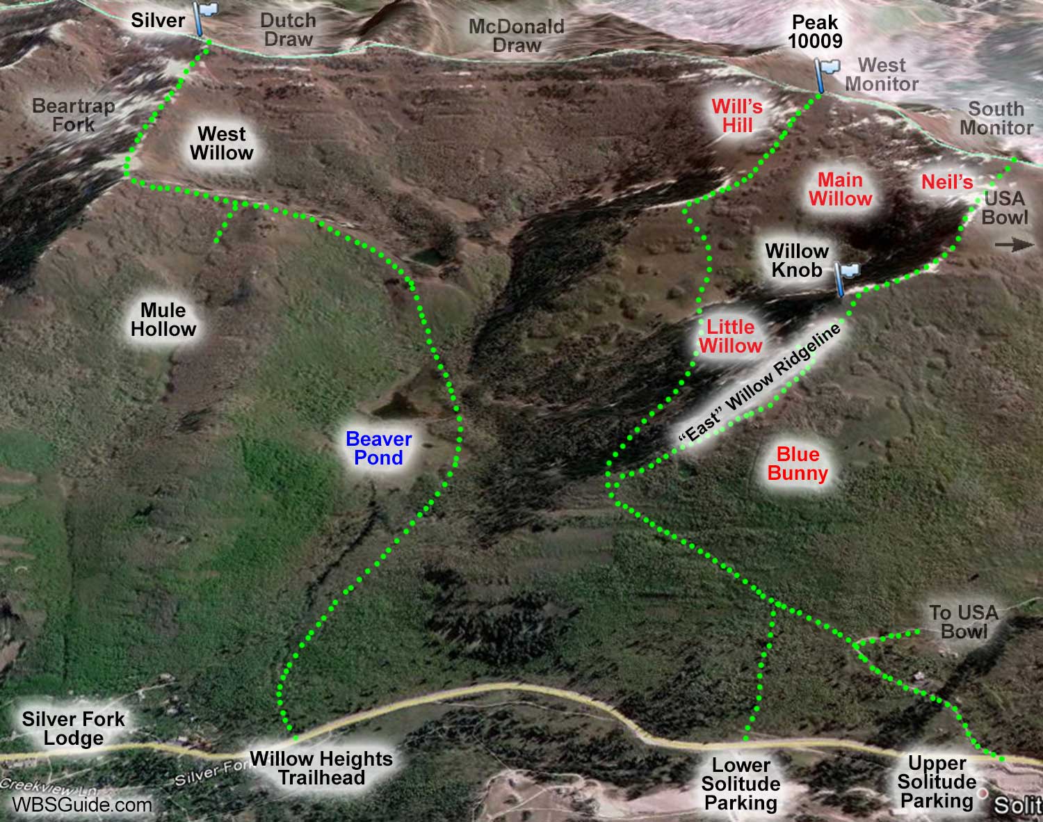
Willow Knob is a nondescript bump on the East Willow Ridgeline. The Knob is usually wind scoured and can be a bit awkward to pass when you are ascending the ridgeline
to access Neil's Bullshit Bowl, USA Bowl, or the South Monitor. The right (south) side of the Knob is usually preferable, although the scoured snow can make skinning difficult. The left (north) side is more likely to be windloaded and avalanche prone.
Park near the lower Solitude parking lot. A skin track
starts across the highway. Ascend this track for about 10 minutes until it joins the
skin track coming from the upper Solitude parking lot (on an old jeep road). After a few minutes, you'll reach a thick
grove of pine trees. Take the skin track that branches off to the right just before the trees and climbs the East Willow Ridgeline to Willow knob. It takes about 30 minutes to ascend the East Willow Ridgeline to Willow Knob.
Parking near Solitude's upper Solitude parking lot requires a little less elevation
gain to access Willow Knob.
From the upper parking lot, head up the private Old Stage Road on the north side of Big Cottonwood road.
After less than 10 minutes, Old Stage Road turns sharply to the right as it heads toward USA Bowl. Follow
the skin track that leaves the road on the outside (left-side) of this turn and climbs modestly along an
abandoned jeep road toward Willow Fork. After about 15 more minutes you'll reach a thick grove of pine
trees where, as mentioned above, a skin track branches off to the right just before the trees and climbs the East Willow Ridgeline to Willow Knob.