Beginner terrain
that is good as you develop your backcountry skills and when the avalanche danger is higher. Click for details.
Intermediate
terrain that requires more experience in skinning and skiing. Click for details.
Advanced terrain
that requires strong skiing and skinning skills. Click for details.
Expert terrain that is
challenging and a small mistake can have serious consequences. Click for details.
Extreme terrain
that includes insanely difficult chute skiing and beyond. Click for details.
The difficulty of this terrain
varies widely. Click for details.
This terrain hasn't
been rated. Click for details.
Although this slope was measured, slopes are not homogeneous—this should be considered approximate. Click for details.
This slope angle was not measured. If you get an accurate slope measurement, please send it to me at info@vRigger.com.
The slope angle varies widely. Click for details.
This is the general direction the slope faces. Click for details.
The Utah Avalanche Center says that dangerous avalanches are not expected in this terrain except during extreme or very unusual conditions. Click for details.
The Utah Avalanche Center says that this is generally low-angle terrain although the route may cross under steep avalanche runout zones. Click for details.
The Utah Avalanche Center says that this terrain has significant exposure to numerous commonly-occurring avalanche paths. Click for details.
The Utah Avalanche Center says that this terrain is exposed to significant avalanche hazards often with multiple terrain traps. Click for details.
This terrain can be accessed by resort skiers without skins. Click for details.
This terrain can be accessed by resort skiers without skins. Snowmobiles are allowed. Click for details.
This terrain is commonly skied by helicopter skiers. Click for details.
This terrain is commonly skied by helicopter skiers and by resort skiers without skins. Click for details.
This terrain is commonly skied by helicopter skiers, by resort skiers without skins, and by snowmobilers. Click for details.
This terrain is commonly skied by helicopter skiers. Snowmobiles are allowed. Click for details.
Snowmobiles are allowed in this terrain. Click for details.
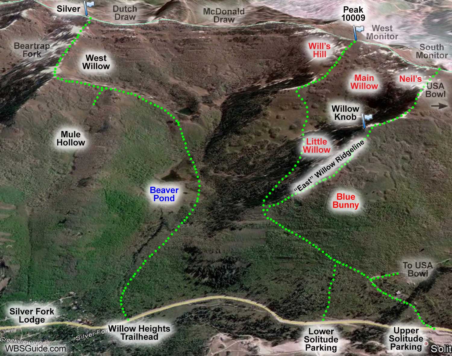
Main Willow is the slope that is on your right as you're skinning up the ridge toward Peak 10009
(see
an overview of Willow Fork)
. It offers good low-angle beginner terrain and is a solid choice when the avalanche hazard is higher.
The skier's right side of Main Willow is a bit more open and is sometimes called Hourglass, because the terrain narrows through several clumps of aspen trees. There is also a good opening through the trees skier's left in Main Willow. The
trees are a bit tight in the center section.
Most of the terrain in Main Willow ranges between 20° and 30°.
After putting in a lap or two in Willow Fork, head back out the skin track to your car. The return trail is narrow and may test your snowplowing quads. If you're returning to the lower Solitude lot, don't depart from the skin track too soon or you'll end up
down-canyon of the parking lot.
Follow these instructions to get to Willow Fork drainage.
Continue into the evergreens that are mentioned at the "split" in those instructions (you'd turn right here
if you wanted to go up the East Willow Ridgeline).
Once you're in
Willow Fork, follow the ridge to the top of Peak 10009. It takes about an hour to go from Solitude to
Peak 10009.


