


| Beartrap Fork | |
|---|---|
| Trailheads |
Beartrap Fork Trailhead
9990 Chairlift |
| Location | 40.6478° / -111.6107° |
| Online Map | View on wbskiing.com |
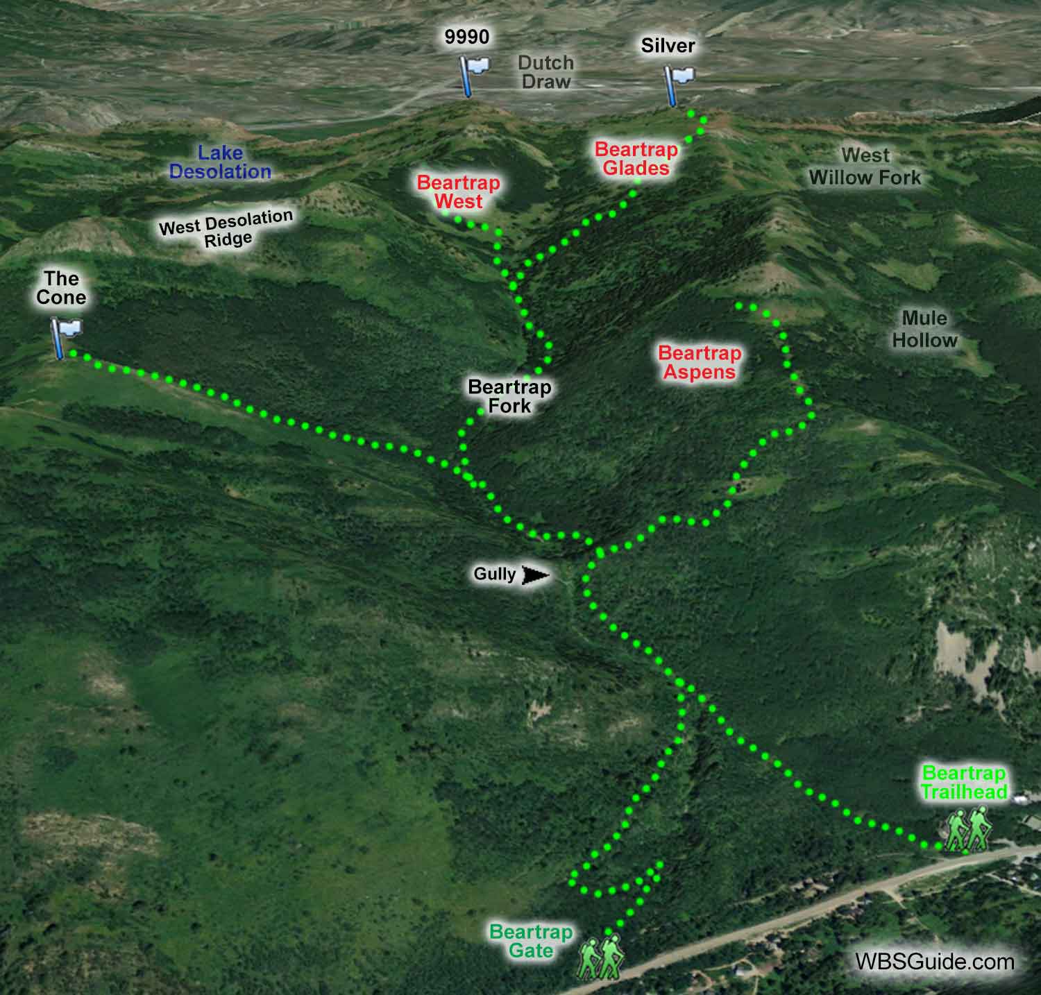
Beartrap Fork is in Big Cottonwood Canyon. It is up-canyon from Mill D North Fork (the drainage that contains Short Swing and Dog Lake) and down-canyon from Mule Hollow and Willow Fork.
Peak 9990 (aka Desolation Peak) is located at the upper-west end of Beartrap Fork and Silver (aka Peak 10006) is located at the upper-east end. Dutch Draw is over the top of the drainage in Summit Country. Park City's Ninety-Nine 90 chairlift provides reasonably easy sidecountry access to Beartrap Fork, although you'll need to skin a short distance back to the resort.
Beartrap Fork provides excellent intermediate terrain with relatively low avalanche hazard. Popular runs in Beartrap Fork include Beartrap Aspens, The Cone, and Beartrap Glades. You can also access Powder Park 3 and Lake Desolation from Beartrap Fork.
|
|
|
| Beartrap Fork Gate | |
|---|---|
| Trailhead Elevation | 7,570' |
| Trailhead Location | 40.6382° / -111.6216° |
| Road Mileage | 10.4 miles |
| Online Map | View on wbskiing.com |
You can access Beartrap Fork from two different, yet nearby, trailheads. One option is to park on the right side of the Big Cottonwood Canyon road 10.4 miles up the canyon just past Rivers End Road (which will be on your right). A skin track starts at a gate on the north (left) side of the Big Cottonwood Canyon road, heads west briefly as it follows a switchbacking Jeep-road up the left side of the Beartrap drainage.
|
|
|
| Beartrap Fork Road | |
|---|---|
| Trailhead Elevation | 7,650' |
| Trailhead Location | 40.6361° / -111.6165° |
| Road Mileage | 10.7 miles |
| Online Map | View on wbskiing.com |
The other starting location is to park 10.7 miles up the road and across from the "Bear Trap Fork Road" sign (which will be on your left). This trail starts on the north (left) side of the Big Cottonwood Canyon road just down-canyon from the "prow house" (you'll know the prow house when you see it). The tracks from both of these trailheads join after about 10 minutes (see photo, above).
A terrain trap gully in the lower portion of Beartrap (labeled on the above photo) has steep walls that frequently avalanche. If the avalanche conditions are safe, you can follow the main skin track into the gully to save a little climbing. If the conditions are even remotely questionable, or if you're headed to the Beartrap Aspens, take the skin track that climbs to the right and bypasses the gully.
When you are returning from your play-day in Beartrap, if you parked at the Bear Trap Fork Road (the second option, above), bear <ha-ha> a little left as you near the road so you don't end up below your car. You'll also want to slow down as you near the Big Cottonwood Canyon road—the aspen trees in lower Beartrap Fork are snug.
About the Name
USGS maps, the Wasatch Ski Atlas, and Hiking the Wasatch spell Beartrap as one word. A few others sources like Backcountry Skiing Utah and the "Bear Trap Fork Road" sign spell it as two words. I'm going with the earlier publications and spelling it as one word.


