Beginner terrain
that is good as you develop your backcountry skills and when the avalanche danger is higher. Click for details.
Intermediate
terrain that requires more experience in skinning and skiing. Click for details.
Advanced terrain
that requires strong skiing and skinning skills. Click for details.
Expert terrain that is
challenging and a small mistake can have serious consequences. Click for details.
Extreme terrain
that includes insanely difficult chute skiing and beyond. Click for details.
The difficulty of this terrain
varies widely. Click for details.
This terrain hasn't
been rated. Click for details.
Although this slope was measured, slopes are not homogeneous—this should be considered approximate. Click for details.
This slope angle was not measured. If you get an accurate slope measurement, please send it to me at info@vRigger.com.
The slope angle varies widely. Click for details.
This is the general direction the slope faces. Click for details.
The Utah Avalanche Center says that dangerous avalanches are not expected in this terrain except during extreme or very unusual conditions. Click for details.
The Utah Avalanche Center says that this is generally low-angle terrain although the route may cross under steep avalanche runout zones. Click for details.
The Utah Avalanche Center says that this terrain has significant exposure to numerous commonly-occurring avalanche paths. Click for details.
The Utah Avalanche Center says that this terrain is exposed to significant avalanche hazards often with multiple terrain traps. Click for details.
This terrain can be accessed by resort skiers without skins. Click for details.
This terrain can be accessed by resort skiers without skins. Snowmobiles are allowed. Click for details.
This terrain is commonly skied by helicopter skiers. Click for details.
This terrain is commonly skied by helicopter skiers and by resort skiers without skins. Click for details.
This terrain is commonly skied by helicopter skiers, by resort skiers without skins, and by snowmobilers. Click for details.
This terrain is commonly skied by helicopter skiers. Snowmobiles are allowed. Click for details.
Snowmobiles are allowed in this terrain. Click for details.
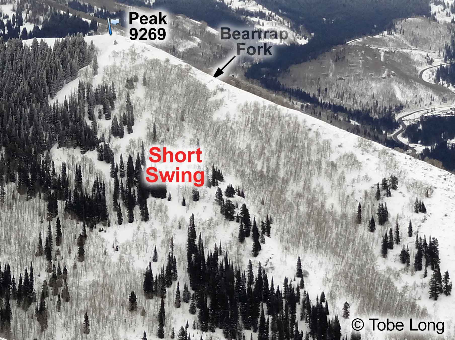
Short Swing's proximity to the road makes it a very popular place—you can ski car-to-car in about two hours.
You can ski through the trees on either side of the Short Swing up track. The runs on the skier's right
tend to be a little steeper than the runs that are skier's left. Be very wary of the steep avalanche terrain
that is north of Peak 9269.
You can also ski east from the top of Short Swing (i.e., Peak 9269) into Beartrap Fork as explained on the page about The Cone, or you can traverse north from
Peak 9269 to go to Powder Park 3, although to do this you'll need to de-skin and re-skin.
Follow the directions to Mill D North Fork from the Spruces trailhead. Approximately 5 minutes after passing the
gate near the end of the cabin road, a skin track leaves the main Mill D North trail on the right. This
track starts just past a clump of fir trees when the trail turns gently to the right. The track then
climbs a subtle ridge through aspens to Peak 9269. The top of Short
Swing is just below the summit of Peak 9269.
This skin track is usually set steeply, but it only takes about an hour-and-a-half to climb the 1,900
feet from your car to the top of Short Swing.