


| Cardiff Fork | |
|---|---|
| Trailheads |
Cardiff Fork Trailhead Central Alta Trailhead |
| Location | 40.6199° / -111.6545° |
| Online Map | View on wbskiing.com |
Cardiff Fork is located in Big Cottonwood Canyon and is also known as Mill D South Fork. This guide uses the more common skier's term of Cardiff Fork. Regardless of the name you prefer, the skiing is epic.
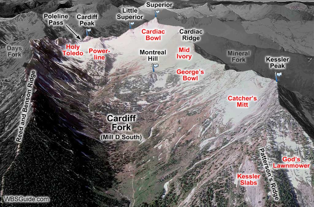
Cardiff Fork is down-canyon from Days Fork and up-canyon from the lesser skied Mineral Fork. The ridge on the east side of Cardiff Fork (that separates Days Fork from Cardiff Fork) is called the Reed and Benson Ridge. Cardiff Peak, Little Superior (aka the Black Knob), and Mount Superior form the ridgeline between Big Cottonwood and Little Cottonwood canyons at the upper end of Cardiff Fork. The pass that connects the two Cottonwood canyons is named Cardiff Pass (aka Poleline Pass). Kessler Peak is at the base of the ridge that separates Cardiff Fork from Mineral Fork. The following picture will help orient you to this landmark drainage.
Upper Cardiff Fork provides some of the most spectacular skiing in the Wasatch mountain range. Its proximity to Alta and Snowbird, and to powder-hungry helicopter skiers, has made it a world-renown playground. Upper Cardiff Fork can be accessed from the Central Alta trailhead, or with significantly more effort, from Big Cottonwood Canyon.
Some of Cardiff Fork is private property which has resulted in conflicts between the land owners and skiers. If you are confronted, please remain calm and be polite—there are better ways to deal with land-use disputes.
As with many of the drainages on the south side of Big Cottonwood Canyon, Cardiff Fork can be accessed from either Big or Little Cottonwood Canyon. Approaching from Little Cottonwood Canyon makes the most sense when skiing runs in upper Cardiff Fork (e.g., Holey Toledo, Powerline, Cardiac Bowl, etc) whereas approaching from Big Cottonwood Canyon makes sense for runs in the lower portion (e.g., George's Bowl, Catcher's Mitt, etc).
| Cardiff Pass from Cardiff Trailhead | |
|---|---|
| Trailhead | Cardiff Fork |
| Ascent Vertical | 2,700' |
| Skinning Distance | 3.0 miles |
| Online Map | View on wbskiing.com |
It's a long haul from Big Cottonwood Canyon to Cardiff Pass, let alone to the ascend the ridge to the top of Superior which is 1,000 feet higher.
Park at the Cardiff Fork trailhead, put on your skins, and head up the (usually) snow covered Cardiff Fork Road. You'll come to the last cabin after about 0.5 miles and the Donut Falls summer parking area after 0.7 miles. Follow the jeep road that continues up the right (west) side of Cardiff Fork. This road is exposed to numerous avalanche paths. This paragraph is purposefully (almost) repeated on 2723.php.
When skiing down Cardiff Fork to Big Cottonwood, it's helpful to bear skier's left and get back on the jeep road as you near the lower portion of the canyon, because the creek in the center of the drainage can be difficult to cross (this is primarily a concern when there is a shallow snowpack).
| Cardiff Pass from Central Alta Trailhead | |
|---|---|
| Trailhead | Central Alta Trailhead |
| Ascent Vertical | 1,300' |
| Skinning Distance | 1.0 miles |
| Online Map | View on wbskiing.com |
The upper end of Cardiff Fork is much easier to access from Little Cottonwood than from Big—it's 1 mile and 1,300 vertical feet from Little versus 4 miles and 2,700 vertical feet from Big. Simply follow the route to Cardiff Pass from the Central Alta trailhead.
You can take advantage of public transportation by leaving your car at the Park and Ride at the mouth of Big Cottonwood Canyon (or the 6400 South Wasatch Park and Ride), taking a bus to the Central Alta trailhead, skinning to Cardiff Pass, skiing to the Cardiff Fork trailhead in Big Cottonwood Canyon, and catching a bus (or thumbing) from there back to your car. Do it!


