


| Mineral Fork | |
|---|---|
| Trailhead | Mineral Fork Trailhead |
| Location | 40.6175° / -111.6825° |
| Online Map | View on wbskiing.com |
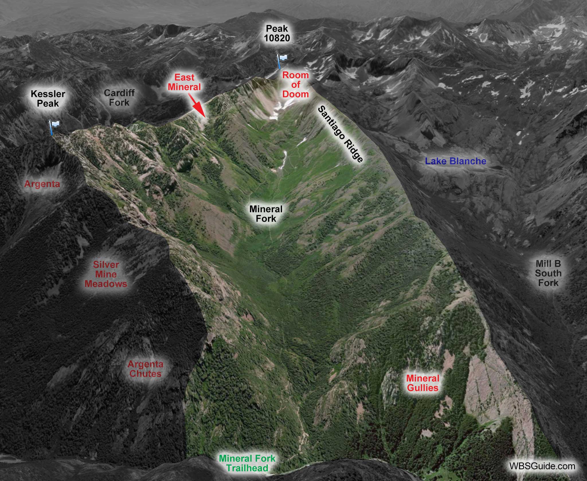
Mineral Fork is on the south side of Big Cottonwood Canyon (don't confuse Mineral Fork in Big Cottonwood with Mineral Basin on the backside of Snowbird).
Unlike the other south-side canyons in Big Cottonwood, the upper end of Mineral Fork does not reach the Little Cottonwood ridgeline. Instead, it is pinched off by its neighbors, Cardiff Fork to the east and Mill B South Fork to the west.
The entire western slope of Mineral Fork is commonly referred to as Santiago Ridge, although the name Santiago originally referred to a specific run further up the drainage.
As with most of the Wasatch mountains, the avalanche hazard in Mineral Fork is significant. Always keep in mind that you can trigger an avalanche from high above you while skiing flatter terrain. On December 11, 2004, snowshoers Bruce Quint and Melvin Dennis died in a remotely triggered avalanche merely by walking up the center of the Mineral Fork drainage.
Mineral Fork has tremendous skiing. The downside, besides the avalanche hazard, is that you have to skin 2.5 miles (and 1,500 vertical feet) to get to the base of most of the skiing. It is time well spent and greatly reduces the number of skiers, but Mineral is unlike much of the Central Wasatch where the skiing starts very close to the road.
Although popular with ATV users in the summer, snowmobiles are not allowed in Mineral Fork. However, helicopters are common.
| Mineral Fork Trailhead | |
|---|---|
| Trailhead Elevation | 6,750' |
| Trailhead Location | 40.6365° / -111.6985° |
| Road Mileage | 5.7 miles |
| Online Map | View on wbskiing.com |
| Upper Mineral from Mineral Trailhead | |
|---|---|
| Trailhead | Mineral Fork Trailhead |
| Skinning Vertical | 3,700' |
| Skinning Distance | 3.5 miles |
| Online Map | View on wbskiing.com |
The Mineral Fork trailhead starts by a cell tower and a brown Forest Service gate on the south side of Big Cottonwood, 5.8 miles past the digital sign (and 1 mile before the Argenta avalanche path).
Park at the trailhead, skin pass the gate, and ascend the road toward your right.
A spring often flows across the switchbacks about a half mile up the trail. Sometimes you can cross the water with a big step while keeping your skis on, sometimes you'll need to take your skis off so you don't get your skins wet, and sometimes you can opt to perform contortionist kick-turns to ascend the steep bank and avoid the wet trail.
It's a long haul to the Room of Doom in upper Mineral Fork. The skinning distance shown in this data table don't include switchbacks, so you'll be skinning further than the 3.5 miles shown here (the summer hiking trail is 4.2 miles long).
The road splits after about an hour-and-a-half with the main track going straight toward the Room of Doom and the left branch heading toward Bengal Tiger and the East Fork.
Coming back down can be slot-car-like (as are many of the routes out of the canyons on the south side of Big Cottonwood Canyon). Don't scare the snowshoers who will jump unpredictably when they hear you are skiing behind them.
When you are on the final switchbacks on the way back down, you can avoid the spring by stopping just before the water and doing a black-diamond sideslip to the next switchback.
| Upper Mineral from Central Alta | |
|---|---|
| Trailhead | Central Alta Trailhead |
| Skinning Vertical | 2,700' |
| Skinning Distance | 1.5 miles |
Follow the instructions to Cardiac Bowl. Then ski about 700 feet down Cardiac Bowl and skin up to the pass that is just north of Peak 10820. Peak 10820 overlooks the Room of Doom in Mineral Fork.
The 2,700 vertical feet shown in the info table includes skiing up after your run down Cardiac Bowl. It's still a thousand feet less vertical than coming in from Big Cottonwood, although if you car is in Little Cottonwood Canyon...


