


| White Pine Fork | |
|---|---|
| Location | 40.5600° / -111.6852° |
| Online Map | View on wbskiing.com |
White Pine Fork is on the south side of Little Cottonwood Canyon. It is west (down-canyon) from the Snowbird ski area and east (up-canyon) from Red Pine Fork. Three 11,000 foot mountains, Red Top Mountain (aka Red Stack), Red Baldy, and White Baldy, cap the upper end of White Pine Fork. The original boundaries of the Lone Peak Wilderness Area, which was created in 1977, protected White Pine Fork from development, but lobbyists for Snowbird had it removed at the last minute.
Runs in the lower portion of White Pine Fork (e.g., Scotties Bowl and Pink Pine) provide easy access for short tours while the spectacular terrain in upper White Pine (e.g., Glacier Bowl, Lake Chute, West Pass, etc) are excellent for longer tours.
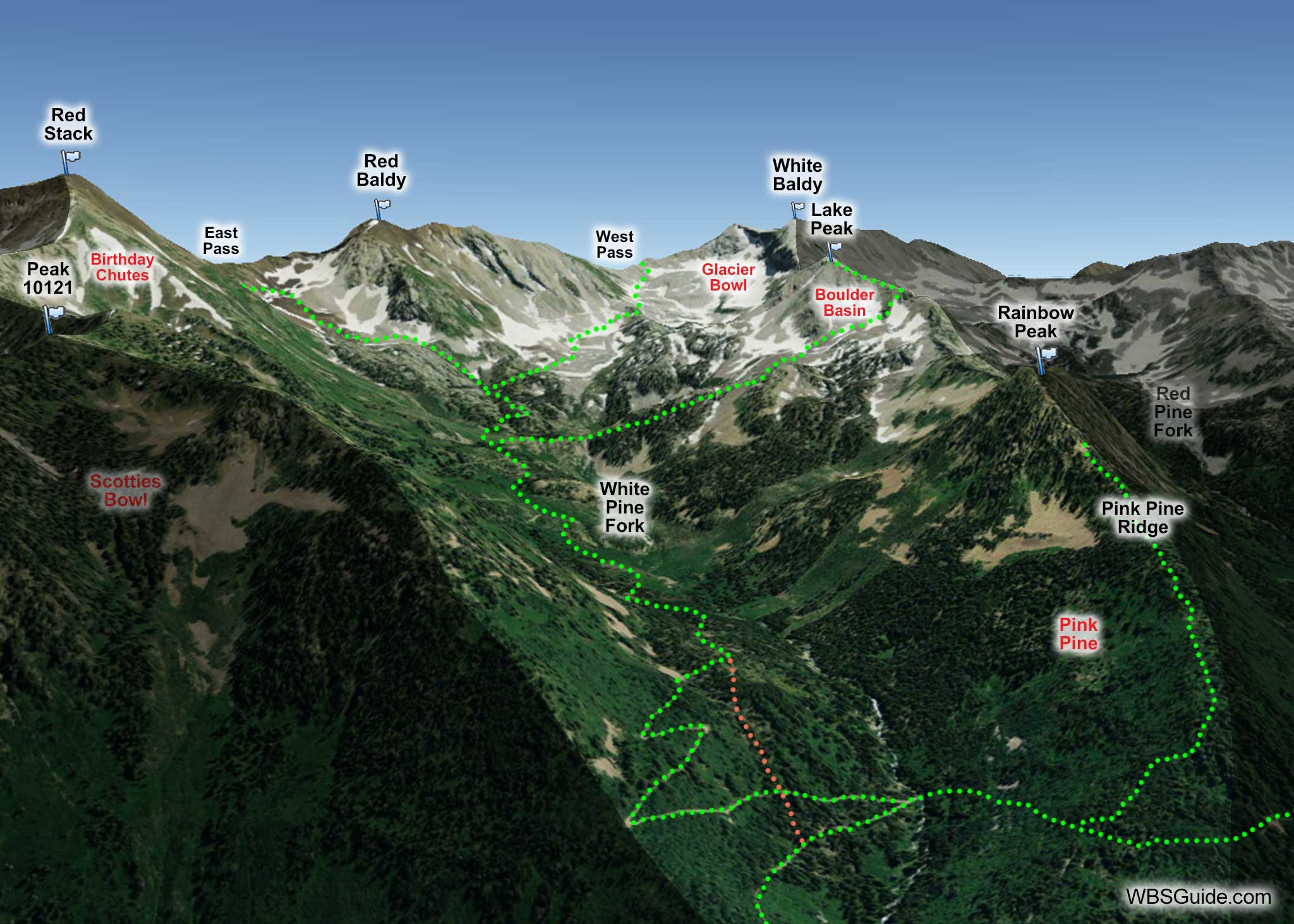
White Pine trailhead is the main access point for White Pine Fork and Red Pine Fork. The trail starts in the southwest corner of the parking lot (near the bathrooms), goes downhill and to your left very briefly, and crosses the Little Cottonwood Canyon creek on a small footbridge.
After less than 30 minutes of gentle climbing on an abandoned road, the trail meets the White Pine Fork creek. The road makes a hard left hand turn at this point and continues up the White Pine Fork road. A smaller trail branches to the right at the turn, crosses the creek, and contours west toward Red Pine Fork. Optionally, and more practical, you can look for a skin track on your left before you reach the creek (shown as an orange dotted line in the above illustration). This switchbacking skin track, although steeper than the road, is the more direct route.
The runs on the east side of White Pine Fork can also be accessed from Snowbird's Gad 2 backcountry gate. You can then thumb a ride from the White Pine trailhead to return to Snowbird.
When existing White Pine Fork, bear high and skiers-right and avoid getting into the bottom of the drainage.
About the Name
The Wasatch Touring Map 2 and the Hiking the Wasatch book show the name as White Pine Canyon. The Wasatch Tours Volume 2 map shows the name as White Pine Gulch. However, the Hiking the Wasatch map and the USGS map (since 1955) show the name, correctly, as White Pine Fork.
Don't confuse White Pine Fork, which is on the south side of the Little Cottonwood Canyon road, with the White Pine avalanche path that is on the north side of the road.


