Beginner terrain
that is good as you develop your backcountry skills and when the avalanche danger is higher. Click for details.
Intermediate
terrain that requires more experience in skinning and skiing. Click for details.
Advanced terrain
that requires strong skiing and skinning skills. Click for details.
Expert terrain that is
challenging and a small mistake can have serious consequences. Click for details.
Extreme terrain
that includes insanely difficult chute skiing and beyond. Click for details.
The difficulty of this terrain
varies widely. Click for details.
This terrain hasn't
been rated. Click for details.
Although this slope was measured, slopes are not homogeneous—this should be considered approximate. Click for details.
This slope angle was not measured. If you get an accurate slope measurement, please send it to me at info@vRigger.com.
The slope angle varies widely. Click for details.
This is the general direction the slope faces. Click for details.
The Utah Avalanche Center says that dangerous avalanches are not expected in this terrain except during extreme or very unusual conditions. Click for details.
The Utah Avalanche Center says that this is generally low-angle terrain although the route may cross under steep avalanche runout zones. Click for details.
The Utah Avalanche Center says that this terrain has significant exposure to numerous commonly-occurring avalanche paths. Click for details.
The Utah Avalanche Center says that this terrain is exposed to significant avalanche hazards often with multiple terrain traps. Click for details.
This terrain can be accessed by resort skiers without skins. Click for details.
This terrain can be accessed by resort skiers without skins. Snowmobiles are allowed. Click for details.
This terrain is commonly skied by helicopter skiers. Click for details.
This terrain is commonly skied by helicopter skiers and by resort skiers without skins. Click for details.
This terrain is commonly skied by helicopter skiers, by resort skiers without skins, and by snowmobilers. Click for details.
This terrain is commonly skied by helicopter skiers. Snowmobiles are allowed. Click for details.
Snowmobiles are allowed in this terrain. Click for details.
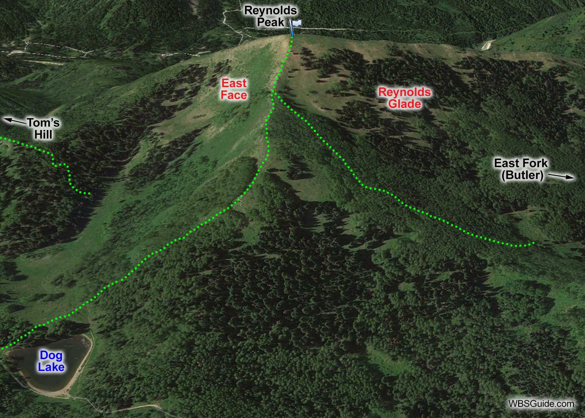
Reynolds Peak is the summit that is on the north side of Big Cottonwood Canyon across from the Donut
Falls sledding area (aka Cardiff Fork). The Butler Fork drainage wraps around the west side of Reynolds
Peak and Mill D North Fork wraps around Reynolds' east side.
Popular runs off of Reynolds include Reynolds Glade, the East Face, and if there's enough snow on the south-facing slope (a rare occurrence), Grand Central.
Summiting Reynolds Peak via Mill D North Fork is a safe ridgeline tour in almost any avalanche
conditions—provided you descend via the same route.
Follow the route to Dog Lake from Big Cottonwood Canyon. The skin track splits at the
Dog Lake with the right track heading toward Little Water Peak and the left track heading toward Reynolds
Peak. Follow the left track as it ascends the ridgeline, skier's right of East Face, to the summit. Be sure to stay clear of any cornices.