


|
|
|
| Gobblers Knob | |
|---|---|
| Summit Elevation | 10,246' |
| Summit Location | 40.6707° / -111.6829° |
| Trailheads |
Butler Fork
Porter Fork |
| Online Map | View on wbskiing.com |
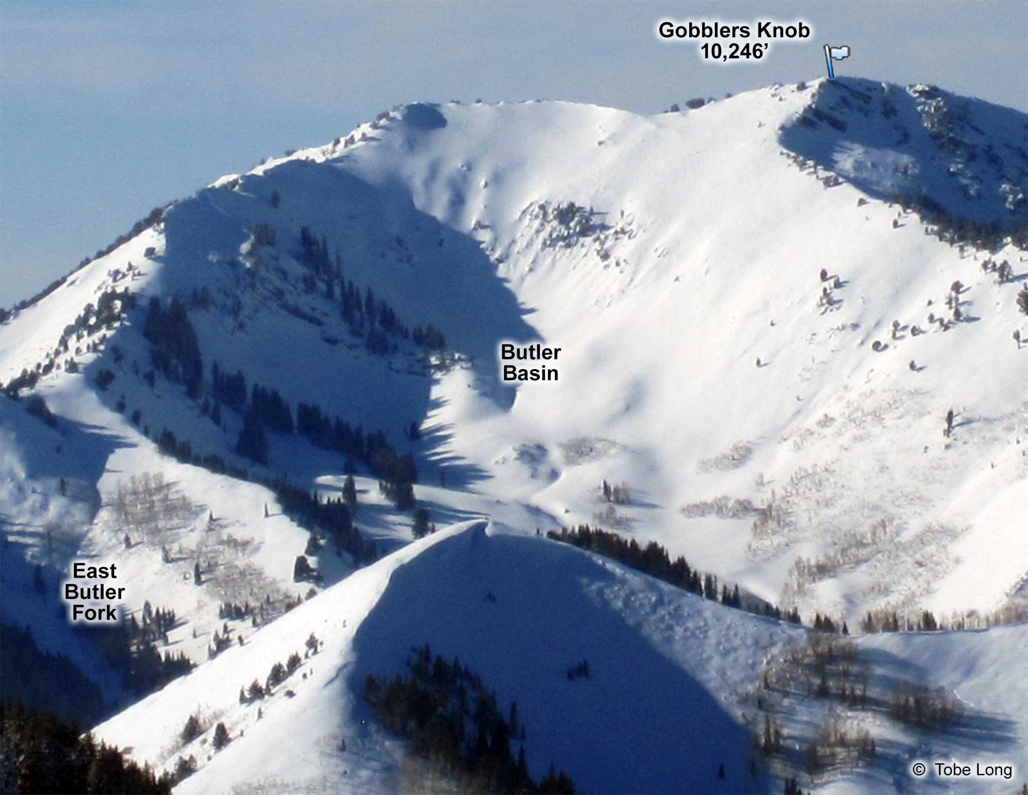
At 10,246 feet, Gobblers Knob is the tallest peak along the ridge that separates Big Cottonwood Canyon from Mill Creek Canyon, although its neighbor to the southeast, Mount Raymond, is only 5 feet shorter.
Gobblers is formed by the junction of the Alexander Basin and Porter Fork drainages in Mill Creek Canyon and the Butler Fork drainage in Big Cottonwood Canyon.
There have been at least four fatalities within a half-mile of the Gobblers Knob summit: one each on the north (Allan Davis), east, and west, and two on the south ( Steve Carruthers and Douglas Green) as well as numerous close calls. ‘Nough said?
Popular runs into the Mill Creek side include Cabin Run, Davis Gulch, and Main Gobblers. Popular runs into the Big Cottonwood side include White Snake and Butler Basin.
There are numerous routes to Gobblers Knob. Although it requires significantly less vertical to ascend from the Big Cottonwood side, the skiing is better in the Mill Creek side. One option is to leave a car at the Maple Grove trailhead in Mill Creek Canyon and then drive a second vehicle to Big Cottonwood Canyon.
|
|
|
| Gobblers Knob from Butler Fork (A) | |
|---|---|
| Trailhead | Butler Fork |
| Trailhead Elevation | 7,140' |
| Summit Elevation | 10,246' |
| Total Vertical | 3,100' |
| Skinning Distance | 3.5 miles |
| Online Map | View on wbskiing.com |
Follow the standard route to Baker Pass from Butler Fork (being aware of the significant avalanche hazard off of Gobblers). Then head east from Baker Pass to the summit of Gobblers Knob.
|
|
|
| Gobblers Knob from Butler Fork (B) | |
|---|---|
| Trailhead | Butler Fork |
| Trailhead Elevation | 7,140' |
| Summit Elevation | 10,246' |
| Total Vertical | 3,100' |
| Skinning Distance | 3.0 miles |
| Online Map | View on wbskiing.com |
Head up Butler Fork from the Butler Fork trailhead, but rather than turning left and going to Baker Pass (as described above), continue up Butler Fork (i.e., stay right). A few minutes after passing Scary Gully (and when Butler Basin is in full view), head up and to your left (i.e., west) and work your way along the ridge to the summit of Gobblers (being careful on the narrow, and often corniced, ridge).
|
|
|
| Gobblers Knob from Porter Fork | |
|---|---|
| Trailhead | Porter Fork |
| Trailhead Elevation | 5,960' |
| Summit Elevation | 10,246' |
| Total Vertical | 4,300' |
| Skinning Distance | 4.0 miles |
| Online Map | View on wbskiing.com |
Park at the Porter Fork trailhead in Mill Creek Canyon. Skin to the end of the Porter Fork Road and then angle toward Baker Pass. (The typical route reaches the ridge between Mill Creek Canyon and Big Cottonwood a little east of Baker Pass). Head east on the ridge to Gobblers Knob.
About the name
According to author and backcountry ski guide Tyson Bradley, Gobblers Knob got its name because, "poverty-stricken miners, looking to augment their meager earnings, raised turkeys on the broad, sloping meadows skiers now love to put signatures on. The birds grazed all across the hill and got water from Baker Spring on the eastern side" of Gobblers.


