


|
|
|
| 10420 | |
|---|---|
| Summit Elevation | 10,420' |
| Summit Location | 40.6001° / -111.5584° |
| Online Map | View on wbskiing.com |
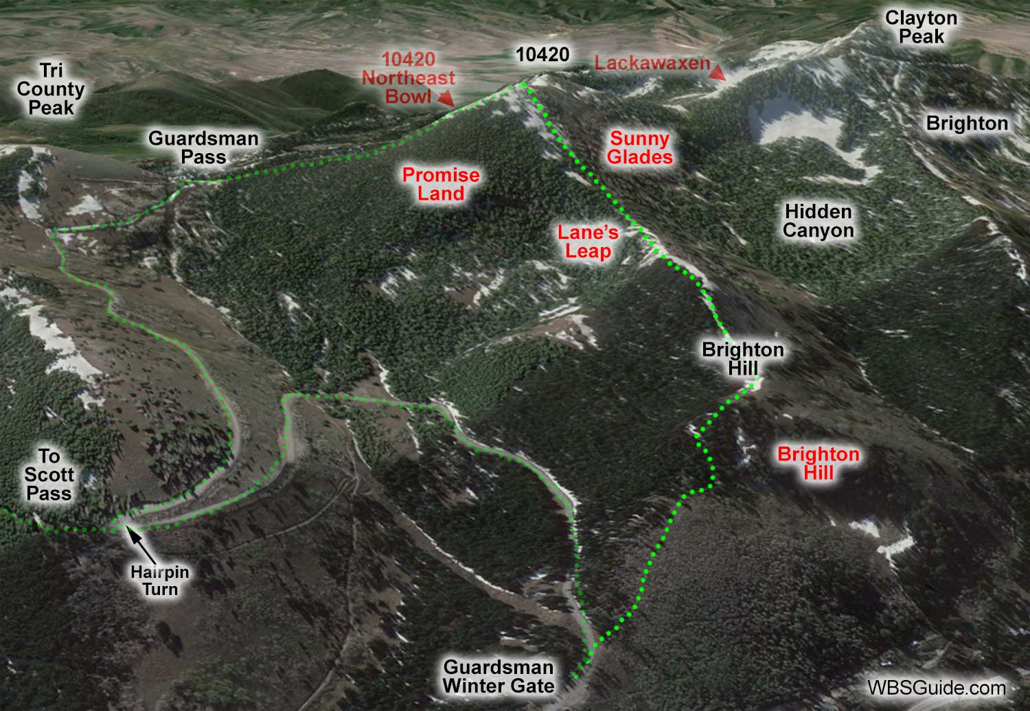
Peak 10420, named for its elevation, is northeast of the top of Brighton's Great Western chairlift (i.e., Clayton Peak). Hidden Canyon, which has been purchased by Brighton <groan>, is the drainage between 10420 and Clayton Peak. The view from the summit of 10420 is spectacular.
There is a false summit about 500 feet to the north of 10420. If you're approaching 10420 from Guardsman Trailhead (rather than from Brighton's Great Western chairlift), most of the runs begin at this false summit. You will know you are on the actual summit when you see the rock arch.
Ten-four-twenty's relatively high elevation makes it a good choice in the early season when there is a shallow snowpack. With minimal snow, you might consider approaching 10420 via Brighton Hill or Guardsman Pass and returning via the snow-covered Guardsman road. If there is more snow, you might try Promise Land, but the trees are a bit tight and there are a fair number of downed trees. You can also ski into Hidden Canyon from 10420, but if Brighton is open for the season, Hidden Canyon is often full of tracks.

| 10420 via Great Western | |
|---|---|
| Trailhead | Great Western Chairlift |
| Saddle Elevation | 10,120' |
| Summit Elevation | 10,420' |
| Booting Vertical | 300' |
| Skinning Distance | 0.25 miles |
| Online Map | View on wbskiing.com |
This is the popular chairlift-boost method of accessing 10420. Ride Brighton's Great Western chairlift, exit the backcountry access gate, ski down to the Hidden Canyon Saddle, boot (or skin) to the top of 10420.
When accessed from Great Western, most people traverse into Hidden Canyon before reaching the 10420 summit.
| 10420 via Brighton Hill | |
|---|---|
| Trailhead | Guardsman Gate |
| Trailhead Elevation | 8,900' |
| Summit Elevation | 10,420 |
| Skinning Vertical | 1,500' |
| Skinning Distance | 1.5 miles |
| Online Map | View on wbskiing.com |
The direct route up 10420 follows the ridge from the Guardsman winter gate to the summit. Immediately after passing the Guardsman gate, bear right (south) onto a trail, which is usually set by snowshoers soon after each storm, and follow the track up the ridge.
After about 10 minutes of skinning and one steeper climb, you'll be on top of the subtle Brighton Hill. About a half-hour from the Guardsman gate you'll reach a flatter stretch along the ridge with a tipped-over, lightning-struck landmark known as Picnic Tree.
The steep clearing that runs from near Picnic Tree into the dense pines on your left is Lane's Leap. Runs named after people almost always indicate an avalanche fatality. Lane's Leap (Lane died in an avalanche here on February 18, 1994) and nearby Brad's Run (Utah's first snowboarder fatality, 18-year-old Brad Lindsey, on February 17, 1986) are good reminders that you're on what might be better named Cemetery Ridge. Staying on the ridgeline is safe; going into the tempting steeper terrain on either side depends on the snowpack.
After about an hour and a half you'll come to an obvious summit that is approximately 500 feet before the actual 10420 summit. From this "false" summit you can ski into Summit County and the Northeast Bowl, ski back toward the Guardsman gate via Promise Land, ski into Hidden Canyon via Sunny Glades, or ski down the northeast ridge to Guardsman Pass and return to your car via the road. If you have a little more ambition you can continue to the actual 10420 summit, which is identifiable by a rock arch.
| 10420 via Guardsman Pass | |
|---|---|
| Trailhead | Guardsman Gate |
| Trailhead Elevation | 8,900' |
| Summit Elevation | 10,420 |
| Skinning Vertical | 1,500' |
| Skinning Distance | 2.0 miles |
| Online Map | View on wbskiing.com |
A third option is to follow the snow-packed road from the Guardsman winter gate to Guardsman Pass, and then follow the ridge to your right (the "northeast ridge") to the above-mentioned "false" summit. It takes about an hour and a half to reach the 10420 false summit using this route.
Give a wide birth to cornices along the ridge that runs from the Guardsman Pass to the summit.
By law, the snowmobilers are supposed to stay on the road when on the Big Cottonwood Canyon side of Guardsman Pass, but they frequently go off trail. You should still be friendly to these folks.


