Beginner terrain
that is good as you develop your backcountry skills and when the avalanche danger is higher. Click for details.
Intermediate
terrain that requires more experience in skinning and skiing. Click for details.
Advanced terrain
that requires strong skiing and skinning skills. Click for details.
Expert terrain that is
challenging and a small mistake can have serious consequences. Click for details.
Extreme terrain
that includes insanely difficult chute skiing and beyond. Click for details.
The difficulty of this terrain
varies widely. Click for details.
This terrain hasn't
been rated. Click for details.
Although this slope was measured, slopes are not homogeneous—this should be considered approximate. Click for details.
This slope angle was not measured. If you get an accurate slope measurement, please send it to me at info@vRigger.com.
The slope angle varies widely. Click for details.
This is the general direction the slope faces. Click for details.
The Utah Avalanche Center says that dangerous avalanches are not expected in this terrain except during extreme or very unusual conditions. Click for details.
The Utah Avalanche Center says that this is generally low-angle terrain although the route may cross under steep avalanche runout zones. Click for details.
The Utah Avalanche Center says that this terrain has significant exposure to numerous commonly-occurring avalanche paths. Click for details.
The Utah Avalanche Center says that this terrain is exposed to significant avalanche hazards often with multiple terrain traps. Click for details.
This terrain can be accessed by resort skiers without skins. Click for details.
This terrain can be accessed by resort skiers without skins. Snowmobiles are allowed. Click for details.
This terrain is commonly skied by helicopter skiers. Click for details.
This terrain is commonly skied by helicopter skiers and by resort skiers without skins. Click for details.
This terrain is commonly skied by helicopter skiers, by resort skiers without skins, and by snowmobilers. Click for details.
This terrain is commonly skied by helicopter skiers. Snowmobiles are allowed. Click for details.
Snowmobiles are allowed in this terrain. Click for details.
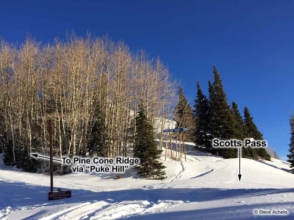
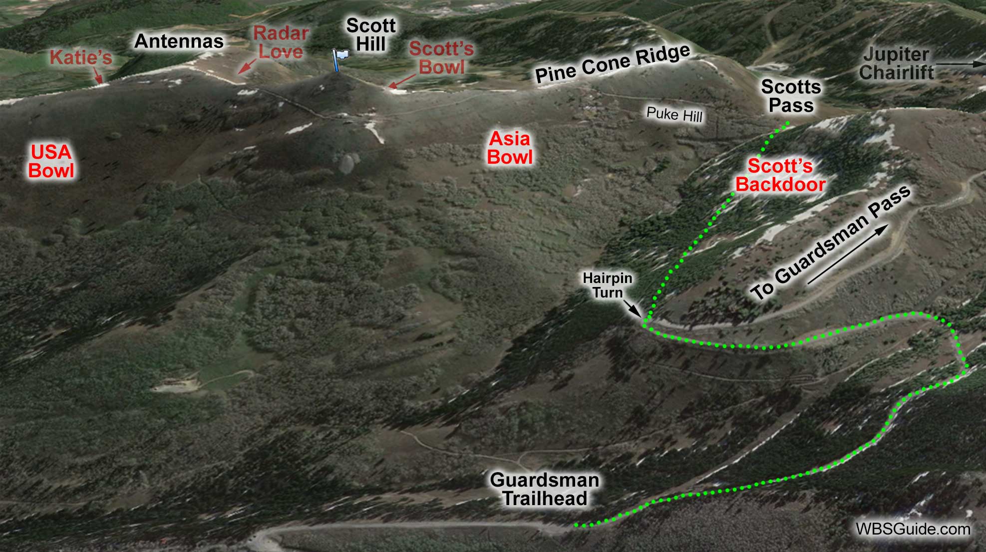
Scotts Pass is located in upper Big Cottonwood Canyon on the border between Salt Lake County and Summit County. It overlooks Park City's Jupiter chairlift (there is even a ski area
trail sign at the pass—boo!). Scotts Pass is on the way to Pinecone Ridge and Scott Hill. The trail to Scotts Pass is popular with snowshoers.
Scotts Pass
Getting to Scotts Pass
Scotts Pass from Guardsman
To reach Scotts Pass, park at the Guardsman winter gate and skin one mile up the
road to a right-hand hairpin turn. (Stay near the side of the road to avoid the snowmobilers.) Take the
access road which leaves the main road on the left side of this hairpin turn (there is a gate about 200
feet up the access road). Follow that road as it crosses below Scott's Backdoor
and arrives
at Scotts Pass. Depending on all the variables, it will probably
take less than an hour to get to the pass from the Guardsman trailhead.
Returning to the trailhead does require some poling on the flat-ish access and Guardsman roads. This
makes this a route little less enjoyable for snowboarders who will probably end up doing some walking.
About the Name
Grammaticians who are concerned that Scott's Backdoor and Scott's Bowl have apostrophes whereas Scotts Pass is missing an apostrophe can relax. The USGS doesn't use apostrophes on
names, so I don't when publishing names that appear on USGS maps. However, I do use apostrophes for possessive
names that were created by backcountry users. Thus, I'm consistently inconsistent.