


| Circle All Peak | |
|---|---|
| Summit Elevation | 8,707' |
| Summit Location | 40.6534° / -111.6739° |
| Trailhead | Butler Fork |
| Online Map | View on wbskiing.com |
Circle All Peak is located just northwest of the Butler Fork trailhead. At 8,707 feet, Circle All Peak is dwarfed by its taller neighbors Mount Raymond (10,241 feet) and Gobblers Knob (10,246 feet). Yet its ease of access from the road, north-facing sheltered slopes, and relatively safe avalanche terrain make it an extremely popular destination.
The stunning views from the summit of Circle All include God's Lawnmower and Argenta on the south side of Big Cottonwood Canyon, and Mount Raymond to the west.
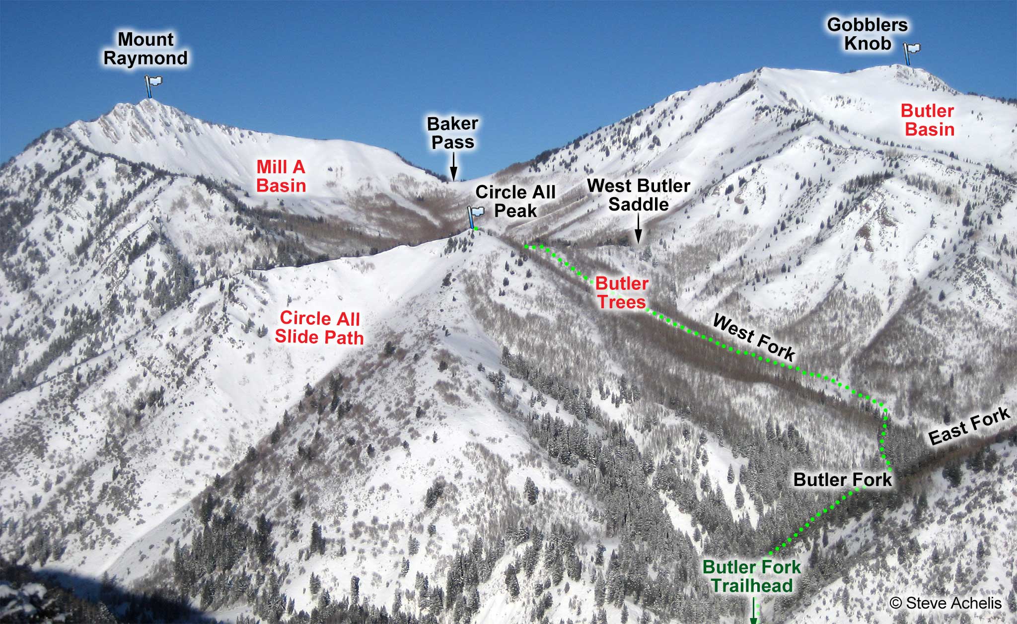
The sheltered northeast facing Butler Trees is the most common decent. Optionally, and possibly for your final lap, you can ski the sometimes sunbaked ridgeline that extends southeast from Circle All Peak to the Butler Fork trailhead.
The south-facing Circle All Slide Path almost always has a thin, crusty snowpack. Skiing it will place you about half mile down-canyon from the Butler Fork trailhead.
| Circle All from Butler Fork | |
|---|---|
| Trailhead | Butler Fork |
| Trailhead Elevation | 7,140' |
| Summit Elevation | 8,707' |
| Total Vertical | 1,600' |
| Skinning Distance | 1.5 miles |
| Ending GPS | 40.6534° / -111.6739° |
| Online Map | View on wbskiing.com |
Park at the Butler Fork trailhead. Follow the Butler Fork trail up the drainage (being leery of the steep slopes on your right) and bear west (left) when it splits between the West and East Butler Forks (details here) . The skin track then zigzags up and to your left through the Butler Trees until it reaches the ridge between Mill A North and Butler Fork just north of Circle All Peak. Head south along the ridge for a few minutes to reach the summit. If you're not breaking trail, it will probably take you a little over an hour to reach the summit of Circle All from your car.
About the name
Most avalanche forecasters spell the name of this peak "Circle Awl," but almost every other resource and printed map spells it "Circle All." And unfortunately, the USGS maps have never shown a name for this peak. I'm sticking with the majority and using "All." I must assume the earliest forecasters heard the name pronounced by a local and misinterpreted the Utah accent ("That there is Circle Y'awl Peak").


