Beginner terrain
that is good as you develop your backcountry skills and when the avalanche danger is higher. Click for details.
Intermediate
terrain that requires more experience in skinning and skiing. Click for details.
Advanced terrain
that requires strong skiing and skinning skills. Click for details.
Expert terrain that is
challenging and a small mistake can have serious consequences. Click for details.
Extreme terrain
that includes insanely difficult chute skiing and beyond. Click for details.
The difficulty of this terrain
varies widely. Click for details.
This terrain hasn't
been rated. Click for details.
Although this slope was measured, slopes are not homogeneous—this should be considered approximate. Click for details.
This slope angle was not measured. If you get an accurate slope measurement, please send it to me at info@vRigger.com.
The slope angle varies widely. Click for details.
This is the general direction the slope faces. Click for details.
The Utah Avalanche Center says that dangerous avalanches are not expected in this terrain except during extreme or very unusual conditions. Click for details.
The Utah Avalanche Center says that this is generally low-angle terrain although the route may cross under steep avalanche runout zones. Click for details.
The Utah Avalanche Center says that this terrain has significant exposure to numerous commonly-occurring avalanche paths. Click for details.
The Utah Avalanche Center says that this terrain is exposed to significant avalanche hazards often with multiple terrain traps. Click for details.
This terrain can be accessed by resort skiers without skins. Click for details.
This terrain can be accessed by resort skiers without skins. Snowmobiles are allowed. Click for details.
This terrain is commonly skied by helicopter skiers. Click for details.
This terrain is commonly skied by helicopter skiers and by resort skiers without skins. Click for details.
This terrain is commonly skied by helicopter skiers, by resort skiers without skins, and by snowmobilers. Click for details.
This terrain is commonly skied by helicopter skiers. Snowmobiles are allowed. Click for details.
Snowmobiles are allowed in this terrain. Click for details.
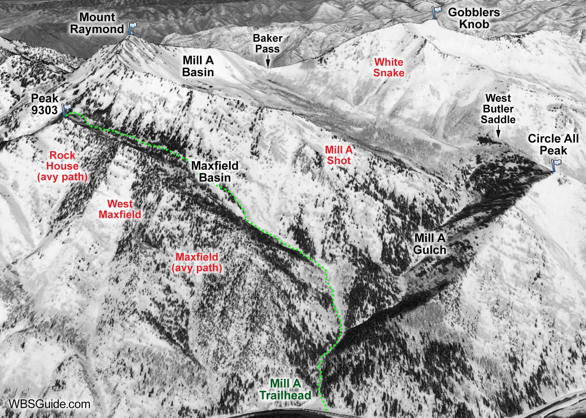
The Mill A trailhead is located on the north (left) side of the Big Cottonwood Canyon road approximately
6.6 miles past the digital sign. The Mill A parking area is usually unplowed and some years parking isn't allowed.
In either case you'll probably need to park 0.4 miles up the canyon at the Argenta trailhead.
About the name
Mill A is the site of the first of six lumber mills, named Mill A through Mill F, that were built in Big Cottonwood Canyon during the 1800s. The letter designations were based on the order that the mills were built without regard to their location in the canyon. The nearby canyons acquired their names from the mills. A total of 19 lumber mills were eventually built in Big Cottonwood Canyon, although not all of them received letter designations.
Mill A was built in the 1850s and was one of the first mills in Big Cottonwood Canyon. It was destroyed by an avalanche in 1856 and there was an avalanche fatality at the mill in 1875.