Beginner terrain
that is good as you develop your backcountry skills and when the avalanche danger is higher. Click for details.
Intermediate
terrain that requires more experience in skinning and skiing. Click for details.
Advanced terrain
that requires strong skiing and skinning skills. Click for details.
Expert terrain that is
challenging and a small mistake can have serious consequences. Click for details.
Extreme terrain
that includes insanely difficult chute skiing and beyond. Click for details.
The difficulty of this terrain
varies widely. Click for details.
This terrain hasn't
been rated. Click for details.
Although this slope was measured, slopes are not homogeneous—this should be considered approximate. Click for details.
This slope angle was not measured. If you get an accurate slope measurement, please send it to me at info@vRigger.com.
The slope angle varies widely. Click for details.
This is the general direction the slope faces. Click for details.
The Utah Avalanche Center says that dangerous avalanches are not expected in this terrain except during extreme or very unusual conditions. Click for details.
The Utah Avalanche Center says that this is generally low-angle terrain although the route may cross under steep avalanche runout zones. Click for details.
The Utah Avalanche Center says that this terrain has significant exposure to numerous commonly-occurring avalanche paths. Click for details.
The Utah Avalanche Center says that this terrain is exposed to significant avalanche hazards often with multiple terrain traps. Click for details.
This terrain can be accessed by resort skiers without skins. Click for details.
This terrain can be accessed by resort skiers without skins. Snowmobiles are allowed. Click for details.
This terrain is commonly skied by helicopter skiers. Click for details.
This terrain is commonly skied by helicopter skiers and by resort skiers without skins. Click for details.
This terrain is commonly skied by helicopter skiers, by resort skiers without skins, and by snowmobilers. Click for details.
This terrain is commonly skied by helicopter skiers. Snowmobiles are allowed. Click for details.
Snowmobiles are allowed in this terrain. Click for details.
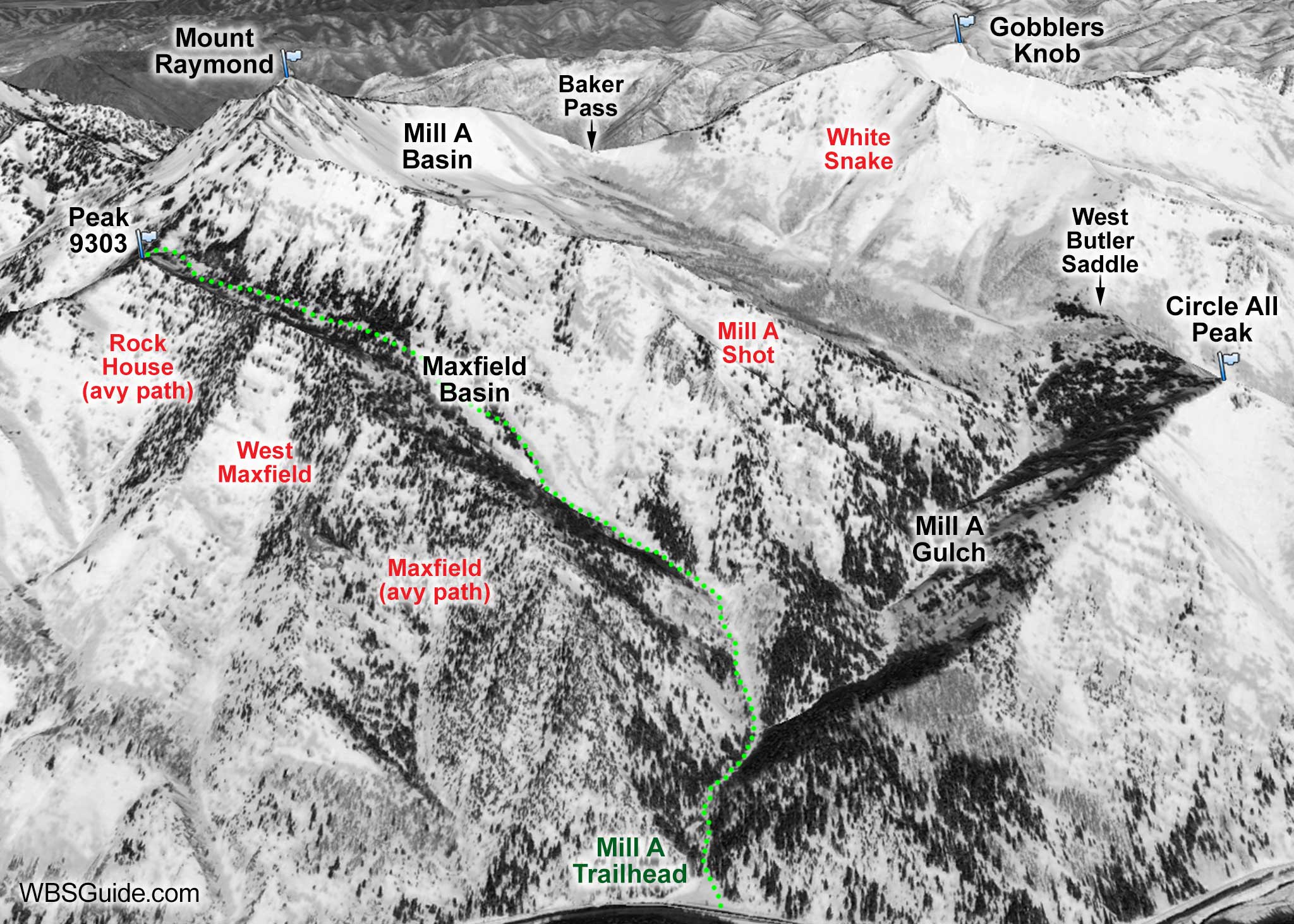
Maxfield Basin is the rarely skied basin that branches westward from lower Mill A Gulch.
The lower two-thirds of the Basin is a long, terrain-trap gully. The Basin continues up to Peak 9303.The runs off the south ridge into the
Basin are avalanche prone yet good.
It's a fairly long hike for the skiing (about three hours to Peak 9303), the roly-poly gully can be cumbersome, and parking
might not be allowed at the mouth of Mill A Gulch during the winter (it wasn't when I skied it a few years ago, but
in 2016 it looks like the "No Parking" sign has been removed). If parking isn't allowed, you can park at the Argenta trailhead and walk 0.4 mile down the road to Mill A.
The Rock House, West Maxfield, and Maxfield avalanche paths all descend from the south
rim of Maxfield Basin to the Big Cottonwood road.
Maxfield Basin and Mill A Gulch
Getting to Maxfield Basin
Head up Mill A about a third of a mile and then bear left up the Maxfield Basin drainage.
About the name
John Maxfield built a mill near the site of Mill A after it was destroyed by an avalanche in 1856. Presumably, Maxfield Basin was named after John. "In 1985, a snow slide swept the mill to the bottom of the fork."