Beginner terrain
that is good as you develop your backcountry skills and when the avalanche danger is higher. Click for details.
Intermediate
terrain that requires more experience in skinning and skiing. Click for details.
Advanced terrain
that requires strong skiing and skinning skills. Click for details.
Expert terrain that is
challenging and a small mistake can have serious consequences. Click for details.
Extreme terrain
that includes insanely difficult chute skiing and beyond. Click for details.
The difficulty of this terrain
varies widely. Click for details.
This terrain hasn't
been rated. Click for details.
Although this slope was measured, slopes are not homogeneous—this should be considered approximate. Click for details.
This slope angle was not measured. If you get an accurate slope measurement, please send it to me at info@vRigger.com.
The slope angle varies widely. Click for details.
This is the general direction the slope faces. Click for details.
The Utah Avalanche Center says that dangerous avalanches are not expected in this terrain except during extreme or very unusual conditions. Click for details.
The Utah Avalanche Center says that this is generally low-angle terrain although the route may cross under steep avalanche runout zones. Click for details.
The Utah Avalanche Center says that this terrain has significant exposure to numerous commonly-occurring avalanche paths. Click for details.
The Utah Avalanche Center says that this terrain is exposed to significant avalanche hazards often with multiple terrain traps. Click for details.
This terrain can be accessed by resort skiers without skins. Click for details.
This terrain can be accessed by resort skiers without skins. Snowmobiles are allowed. Click for details.
This terrain is commonly skied by helicopter skiers. Click for details.
This terrain is commonly skied by helicopter skiers and by resort skiers without skins. Click for details.
This terrain is commonly skied by helicopter skiers, by resort skiers without skins, and by snowmobilers. Click for details.
This terrain is commonly skied by helicopter skiers. Snowmobiles are allowed. Click for details.
Snowmobiles are allowed in this terrain. Click for details.
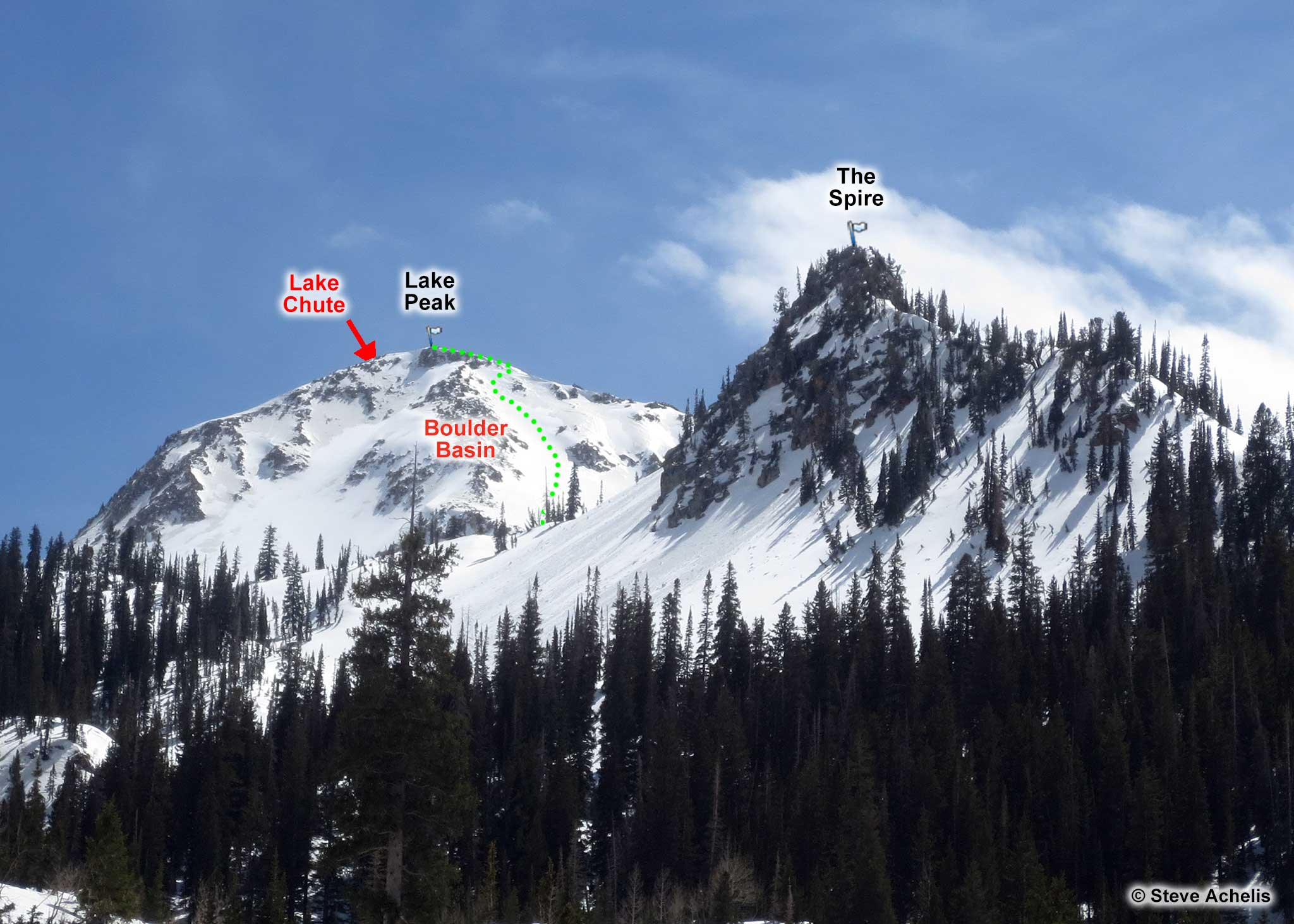
Lake Peak (read about the name) is located on the western side of upper White Pine Fork. It is a
beautiful mountain with fantastic views and an awesome descent down Lake Chute.
One option is to skin to White Pine Lake and then boot up Lake Chute. This option is more appropriate in the spring when the snow is firm. If you do choose to boot, put your booter to the side and don't ascend if doing so will prevent others from descending.
The other options involve ascending Boulder Basin via the route of least resistance. You can go on either side of the Spire to get to Boulder Basin (probably based on the existing skin tracks). The more challenging route is to go up the northeast couloir (lookers left in the above photo). The more practical route is to work your way to the northwest ridge and follow it to the summit (the dotted line in the photo).
About the Name
It is ironic that this is sometimes called No Name Peak, because in fact it has four names: Lake Peak,
Lightning Peak, No Name Peak, and Thunder Mountain.
The most popular names are Lake Peak and No Name Peak (which should not be confused with No Name Baldy which is near the Pfeifferhorn). The name Lake Peak is unquestionably the most popular name.
The name Thunder Mountain has only been on the USGS map since 1998 and is extremely questionable (there is already a Thunder Mountain, with North and South peaks, in Little Cottonwood Canyon).