Beginner terrain
that is good as you develop your backcountry skills and when the avalanche danger is higher. Click for details.
Intermediate
terrain that requires more experience in skinning and skiing. Click for details.
Advanced terrain
that requires strong skiing and skinning skills. Click for details.
Expert terrain that is
challenging and a small mistake can have serious consequences. Click for details.
Extreme terrain
that includes insanely difficult chute skiing and beyond. Click for details.
The difficulty of this terrain
varies widely. Click for details.
This terrain hasn't
been rated. Click for details.
Although this slope was measured, slopes are not homogeneous—this should be considered approximate. Click for details.
This slope angle was not measured. If you get an accurate slope measurement, please send it to me at info@vRigger.com.
The slope angle varies widely. Click for details.
This is the general direction the slope faces. Click for details.
The Utah Avalanche Center says that dangerous avalanches are not expected in this terrain except during extreme or very unusual conditions. Click for details.
The Utah Avalanche Center says that this is generally low-angle terrain although the route may cross under steep avalanche runout zones. Click for details.
The Utah Avalanche Center says that this terrain has significant exposure to numerous commonly-occurring avalanche paths. Click for details.
The Utah Avalanche Center says that this terrain is exposed to significant avalanche hazards often with multiple terrain traps. Click for details.
This terrain can be accessed by resort skiers without skins. Click for details.
This terrain can be accessed by resort skiers without skins. Snowmobiles are allowed. Click for details.
This terrain is commonly skied by helicopter skiers. Click for details.
This terrain is commonly skied by helicopter skiers and by resort skiers without skins. Click for details.
This terrain is commonly skied by helicopter skiers, by resort skiers without skins, and by snowmobilers. Click for details.
This terrain is commonly skied by helicopter skiers. Snowmobiles are allowed. Click for details.
Snowmobiles are allowed in this terrain. Click for details.
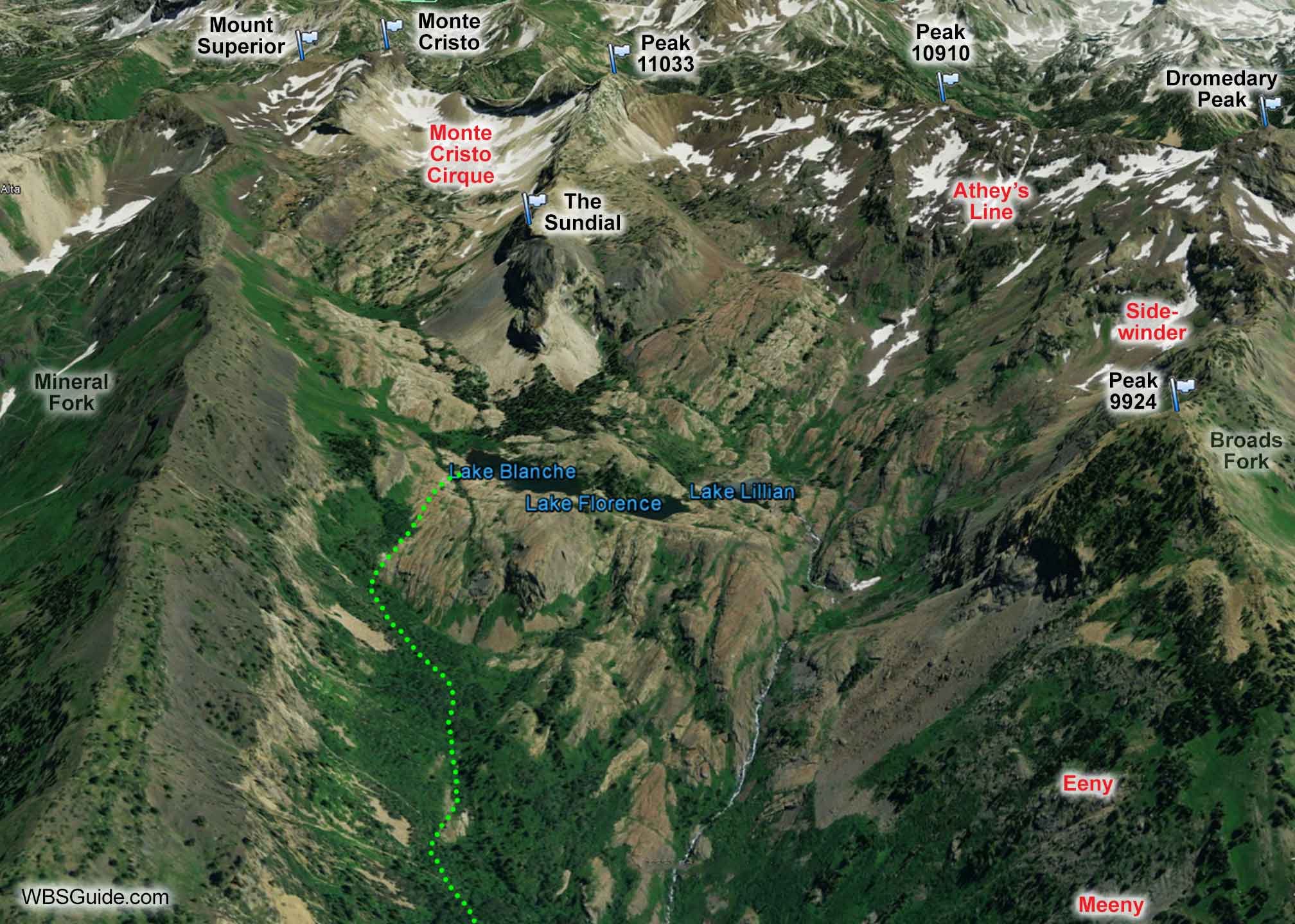
Going to Lake Blanche is an extremely scenic tour with beginner to intermediate skiing, although it is exposed to steep avalanche terrain. From the lakes you will have a great view of The Sundial, Mount Superior, and Monte Cristo.
Upper Mill B South Fork
The skiing on the slope below the lakes is good intermediate terrain. However, below there Mill B South Fork can feel pinball-like and you may need to snowplow through the snug trees.
Park at the Mill B South trailhead. The trail begins on the far (southeast) corner
of the parking lot as a paved (and hopefully snow-covered) road that heads east. After a few minutes, and just before the road crosses a bridge, the Mill B South Fork trail departs to the right. The trail quickly crosses a small footbridge over the Mill B South Fork creek and switchbacks up the hill. The trail stays on the left (east) side of the creek as it heads up the Mill B drainage. Eeny, Meeny, Miny, and Moe are the main runs on the right (west) side of Mill B South (there is significant avalanche exposure all along this east-facing ridge). As it nears the three lakes, the skin track bears to your left (east) and comes out near Lake Blanche.
This route is popular with snowshoers—let's hope they are avy-savvy shoers.