Beginner terrain
that is good as you develop your backcountry skills and when the avalanche danger is higher. Click for details.
Intermediate
terrain that requires more experience in skinning and skiing. Click for details.
Advanced terrain
that requires strong skiing and skinning skills. Click for details.
Expert terrain that is
challenging and a small mistake can have serious consequences. Click for details.
Extreme terrain
that includes insanely difficult chute skiing and beyond. Click for details.
The difficulty of this terrain
varies widely. Click for details.
This terrain hasn't
been rated. Click for details.
Although this slope was measured, slopes are not homogeneous—this should be considered approximate. Click for details.
This slope angle was not measured. If you get an accurate slope measurement, please send it to me at info@vRigger.com.
The slope angle varies widely. Click for details.
This is the general direction the slope faces. Click for details.
The Utah Avalanche Center says that dangerous avalanches are not expected in this terrain except during extreme or very unusual conditions. Click for details.
The Utah Avalanche Center says that this is generally low-angle terrain although the route may cross under steep avalanche runout zones. Click for details.
The Utah Avalanche Center says that this terrain has significant exposure to numerous commonly-occurring avalanche paths. Click for details.
The Utah Avalanche Center says that this terrain is exposed to significant avalanche hazards often with multiple terrain traps. Click for details.
This terrain can be accessed by resort skiers without skins. Click for details.
This terrain can be accessed by resort skiers without skins. Snowmobiles are allowed. Click for details.
This terrain is commonly skied by helicopter skiers. Click for details.
This terrain is commonly skied by helicopter skiers and by resort skiers without skins. Click for details.
This terrain is commonly skied by helicopter skiers, by resort skiers without skins, and by snowmobilers. Click for details.
This terrain is commonly skied by helicopter skiers. Snowmobiles are allowed. Click for details.
Snowmobiles are allowed in this terrain. Click for details.
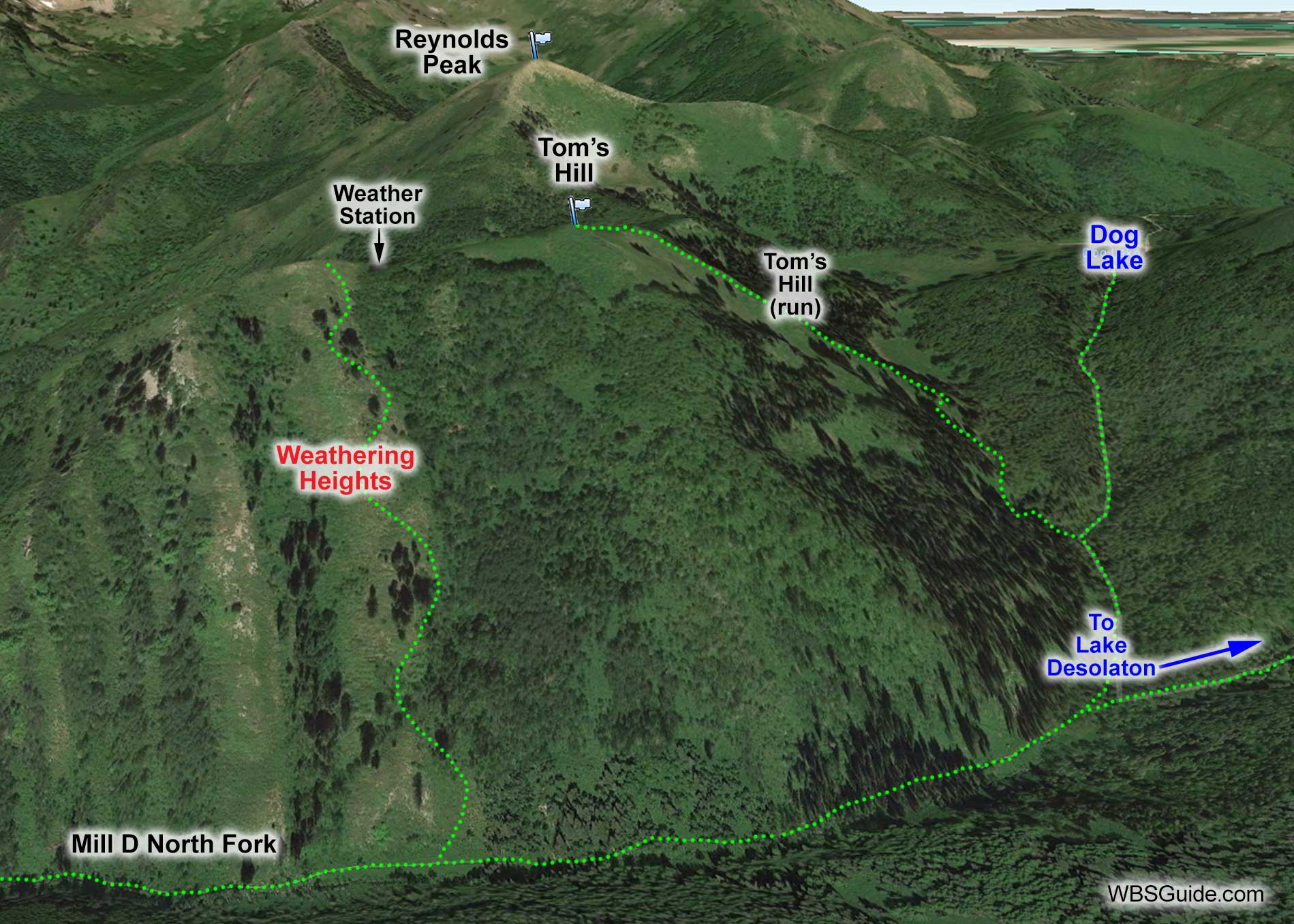
There is a weather station 500 feet south of the summit of Tom's Hill. Weathering Heights descends from near this weather station
(typically a few hundred feet south of it) all the way to the main Mill D North Fork trail.
When the conditions are good Weathering Heights is great, but due to its easterly aspect it is often sun-crusted. When crusty, the snow is usually better in the trees that are skier's left of Weathering Heights.
Weathering Heights and Adjacent Terrain
Although Weathering Heights averages a relatively safe 28°, it does steepen just above the Mill D North Fork trail.
Getting to Weathering Heights
The direct route to Weathering Heights is to follow the directions to Mill D North Fork from the Spruces trailhead. About a thousand feet after the main trail crosses to the east side of the Mill D North creek, a skin track (usually) heads directly up Weathering Heights on the left.
The other option is approach Weathering Heights from Tom's Hill. This is a common approach after skiing Reynolds Peak. Weathering Heights is 500 to 1,000 south of Tom's Hill depending on which line you want to ski.
About the name
Milton Hollander bestowed the name Weathering Heights circa 1989.