Beginner terrain
that is good as you develop your backcountry skills and when the avalanche danger is higher. Click for details.
Intermediate
terrain that requires more experience in skinning and skiing. Click for details.
Advanced terrain
that requires strong skiing and skinning skills. Click for details.
Expert terrain that is
challenging and a small mistake can have serious consequences. Click for details.
Extreme terrain
that includes insanely difficult chute skiing and beyond. Click for details.
The difficulty of this terrain
varies widely. Click for details.
This terrain hasn't
been rated. Click for details.
Although this slope was measured, slopes are not homogeneous—this should be considered approximate. Click for details.
This slope angle was not measured. If you get an accurate slope measurement, please send it to me at info@vRigger.com.
The slope angle varies widely. Click for details.
This is the general direction the slope faces. Click for details.
The Utah Avalanche Center says that dangerous avalanches are not expected in this terrain except during extreme or very unusual conditions. Click for details.
The Utah Avalanche Center says that this is generally low-angle terrain although the route may cross under steep avalanche runout zones. Click for details.
The Utah Avalanche Center says that this terrain has significant exposure to numerous commonly-occurring avalanche paths. Click for details.
The Utah Avalanche Center says that this terrain is exposed to significant avalanche hazards often with multiple terrain traps. Click for details.
This terrain can be accessed by resort skiers without skins. Click for details.
This terrain can be accessed by resort skiers without skins. Snowmobiles are allowed. Click for details.
This terrain is commonly skied by helicopter skiers. Click for details.
This terrain is commonly skied by helicopter skiers and by resort skiers without skins. Click for details.
This terrain is commonly skied by helicopter skiers, by resort skiers without skins, and by snowmobilers. Click for details.
This terrain is commonly skied by helicopter skiers. Snowmobiles are allowed. Click for details.
Snowmobiles are allowed in this terrain. Click for details.
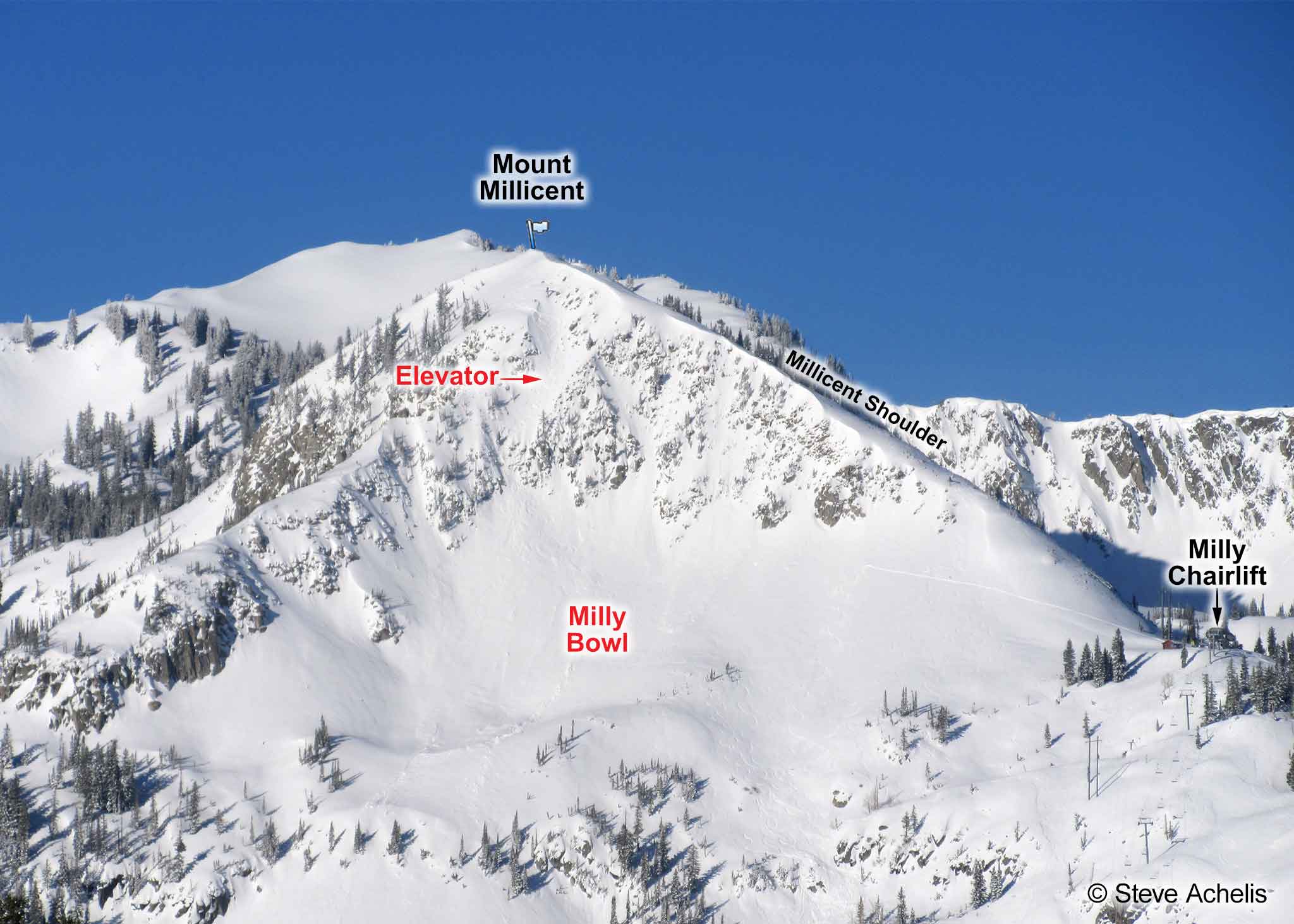
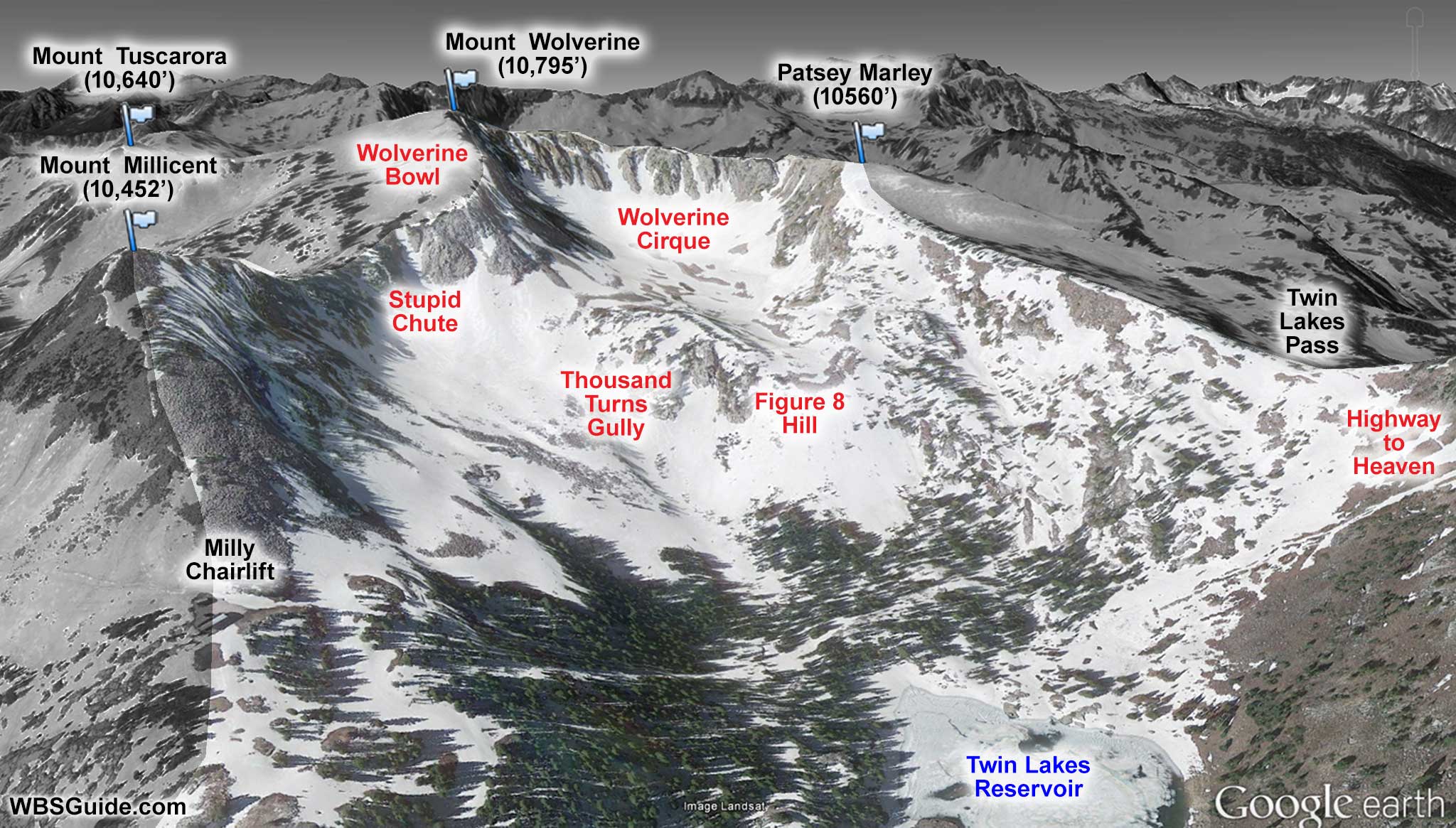
Mount Millicent is the peak above Millicent Bowl at the
Brighton ski area. It is usually accessed by
hitching a ride on the
Milly chairlift and then booting up the Millicent Shoulder.
When avalanche conditions warrant,
the Brighton ski patrol closes the hike up the Shoulder so an avalanche won't endanger their guests.
Sometimes the patrol will open the hike with instructions to not ski into the Milly Bowl—if you ignore
those instructions, you'll end up talking to a judge.
The purist's approach is to start in the Brighton parking lot, skin to the top of Milly (adhering to Brighton's
uphill policy), exit the
Milly backcountry gate, and boot the Millicent Shoulder. That's 1,700 vertical feet over 1.2 miles.
The easy way to get to Mount Millicent is to ride Brighton's
Milly chairlift, exit the
Milly backcountry gate, and boot up the Millicent Shoulder to the summit. That hike is 600 vertical feet over 0.3 miles.
The Millicent Shoulder is steep and should be booted rather than skinned. The booting is much more difficult when the snowpack is thin, because you'll be ascending rock rather than snow, or soft, because you'll be post-holing. Depending on conditions, it will take
10 to 30+ minutes to ascend from the Milly backcountry gate to the summit.


